You are here: Home > Network List > GT - Global Telemetered Seismograph Network (USAF/USGS) Stations List
> Station LPAZ La Paz , Bolivia > Earthquake Result Viewer
LPAZ La Paz , Bolivia - Earthquake Result Viewer
| Earthquake location: |
Southern Mid-Atlantic Ridge |
| Earthquake latitude/longitude: |
-35.4/-17.4 |
| Earthquake time(UTC): |
2015/06/17 (168) 12:51:33 GMT |
| Earthquake Depth: |
10 km |
| Earthquake Magnitude: |
6.1 MB |
| Earthquake Catalog/Contributor: |
NEIC PDE/NEIC ALERT |
|
| Network: |
GT Global Telemetered Seismograph Network (USAF/USGS) |
| Station: |
LPAZ La Paz , Bolivia |
| Lat/Lon: |
16.17 S/68.08 W |
| Elevation: |
4817 m |
|
| Distance: |
48.9 deg |
| Az: |
279.516 deg |
| Baz: |
122.975 deg |
| Ray Param: |
0.0690484 |
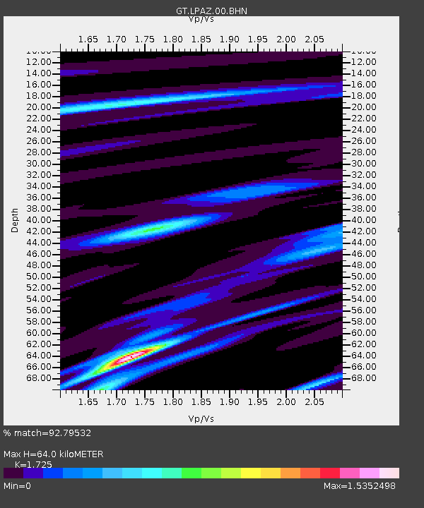
| Estimated Moho Depth: |
64.0 km |
| Estimated Crust Vp/Vs: |
1.73 |
| Assumed Crust Vp: |
6.454 km/s |
| Estimated Crust Vs: |
3.741 km/s |
| Estimated Crust Poisson's Ratio: |
0.25 |
|
| Radial Match: |
92.79532 % |
| Radial Bump: |
400 |
| Transverse Match: |
81.56762 % |
| Transverse Bump: |
400 |
| SOD ConfigId: |
976571 |
| Insert Time: |
2015-07-01 13:08:30.043 +0000 |
| GWidth: |
2.5 |
| Max Bumps: |
400 |
| Tol: |
0.001 |
|

Signal To Noise
| Channel | StoN | STA | LTA |
| GT:LPAZ:00:BHZ:20150617T12:59:48.099994Z | 1.2499117 | 1.447376E-7 | 1.1579826E-7 |
| GT:LPAZ:00:BHN:20150617T12:59:48.099994Z | 0.69428223 | 8.2012015E-8 | 1.1812489E-7 |
| GT:LPAZ:00:BHE:20150617T12:59:48.099994Z | 1.1022906 | 7.112854E-8 | 6.452793E-8 |
| Arrivals |
| Ps | 7.6 SECOND |
| PpPs | 25 SECOND |
| PsPs/PpSs | 33 SECOND |


