You are here: Home > Network List > EI - Irish National Seismic Network (INSN) Stations List
> Station ILTH Corrakit Louth > Earthquake Result Viewer
ILTH Corrakit Louth - Earthquake Result Viewer
| Earthquake location: |
Peru-Brazil Border Region |
| Earthquake latitude/longitude: |
-10.1/-71.1 |
| Earthquake time(UTC): |
2015/11/24 (328) 22:50:53 GMT |
| Earthquake Depth: |
595 km |
| Earthquake Magnitude: |
5.9 MB |
| Earthquake Catalog/Contributor: |
NEIC PDE/NEIC COMCAT |
|
| Network: |
EI Irish National Seismic Network (INSN) |
| Station: |
ILTH Corrakit Louth |
| Lat/Lon: |
54.06 N/6.27 W |
| Elevation: |
227 m |
|
| Distance: |
83.9 deg |
| Az: |
32.45 deg |
| Baz: |
243.654 deg |
| Ray Param: |
0.044104606 |
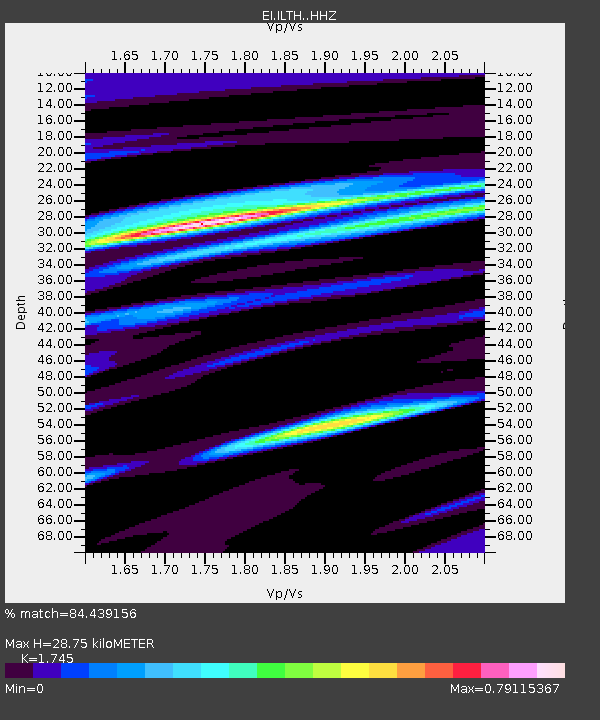
| Estimated Moho Depth: |
28.75 km |
| Estimated Crust Vp/Vs: |
1.75 |
| Assumed Crust Vp: |
6.276 km/s |
| Estimated Crust Vs: |
3.596 km/s |
| Estimated Crust Poisson's Ratio: |
0.26 |
|
| Radial Match: |
84.439156 % |
| Radial Bump: |
400 |
| Transverse Match: |
70.36153 % |
| Transverse Bump: |
400 |
| SOD ConfigId: |
7422571 |
| Insert Time: |
2019-04-21 11:44:20.716 +0000 |
| GWidth: |
2.5 |
| Max Bumps: |
400 |
| Tol: |
0.001 |
|

Signal To Noise
| Channel | StoN | STA | LTA |
| EI:ILTH: :HHZ:20151124T23:01:48.869995Z | 12.3828335 | 3.0729752E-5 | 2.4816413E-6 |
| EI:ILTH: :HHN:20151124T23:01:48.869995Z | 3.4880679 | 4.794021E-6 | 1.3744059E-6 |
| EI:ILTH: :HHE:20151124T23:01:48.869995Z | 7.5849137 | 8.757259E-6 | 1.1545627E-6 |
| Arrivals |
| Ps | 3.5 SECOND |
| PpPs | 12 SECOND |
| PsPs/PpSs | 16 SECOND |


