You are here: Home > Network List > II - Global Seismograph Network (GSN - IRIS/IDA) Stations List
> Station CMLA Cha de Macela, Sao Miguel Island, Azores > Earthquake Result Viewer
CMLA Cha de Macela, Sao Miguel Island, Azores - Earthquake Result Viewer
| Earthquake location: |
Peru-Brazil Border Region |
| Earthquake latitude/longitude: |
-10.1/-71.1 |
| Earthquake time(UTC): |
2015/11/24 (328) 22:50:53 GMT |
| Earthquake Depth: |
595 km |
| Earthquake Magnitude: |
5.9 MB |
| Earthquake Catalog/Contributor: |
NEIC PDE/NEIC COMCAT |
|
| Network: |
II Global Seismograph Network (GSN - IRIS/IDA) |
| Station: |
CMLA Cha de Macela, Sao Miguel Island, Azores |
| Lat/Lon: |
37.76 N/25.52 W |
| Elevation: |
429 m |
|
| Distance: |
63.9 deg |
| Az: |
39.057 deg |
| Baz: |
231.525 deg |
| Ray Param: |
0.05702663 |
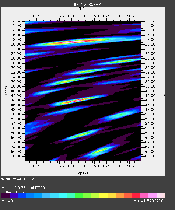
| Estimated Moho Depth: |
18.75 km |
| Estimated Crust Vp/Vs: |
1.80 |
| Assumed Crust Vp: |
4.802 km/s |
| Estimated Crust Vs: |
2.664 km/s |
| Estimated Crust Poisson's Ratio: |
0.28 |
|
| Radial Match: |
89.31692 % |
| Radial Bump: |
400 |
| Transverse Match: |
79.046165 % |
| Transverse Bump: |
400 |
| SOD ConfigId: |
7422571 |
| Insert Time: |
2019-04-21 11:45:06.014 +0000 |
| GWidth: |
2.5 |
| Max Bumps: |
400 |
| Tol: |
0.001 |
|
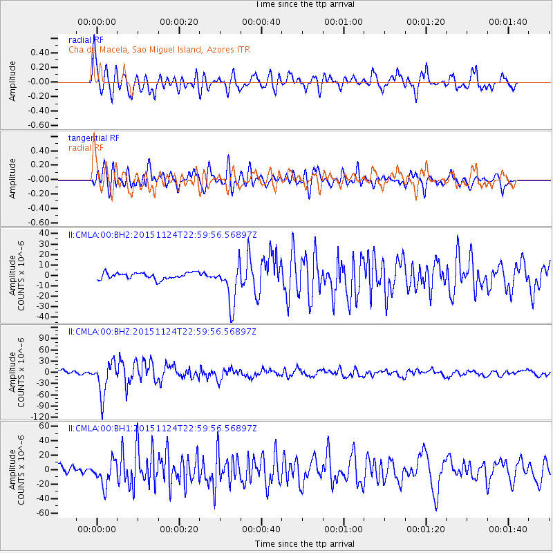
Signal To Noise
| Channel | StoN | STA | LTA |
| II:CMLA:00:BHZ:20151124T22:59:56.56897Z | 10.578199 | 4.495573E-5 | 4.249847E-6 |
| II:CMLA:00:BH1:20151124T22:59:56.56897Z | 4.013684 | 1.758068E-5 | 4.380185E-6 |
| II:CMLA:00:BH2:20151124T22:59:56.56897Z | 7.13496 | 2.0843436E-5 | 2.9213106E-6 |
| Arrivals |
| Ps | 3.2 SECOND |
| PpPs | 11 SECOND |
| PsPs/PpSs | 14 SECOND |


