You are here: Home > Network List > NI - North-East Italy Broadband Network Stations List
> Station FUSE Fusea > Earthquake Result Viewer
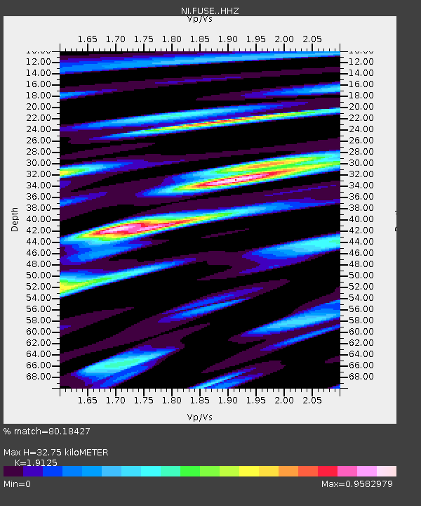
FUSE Fusea - Earthquake Result Viewer
| Earthquake location: |
Peru-Brazil Border Region |
| Earthquake latitude/longitude: |
-10.1/-71.1 |
| Earthquake time(UTC): |
2015/11/24 (328) 22:50:53 GMT |
| Earthquake Depth: |
595 km |
| Earthquake Magnitude: |
5.9 MB |
| Earthquake Catalog/Contributor: |
NEIC PDE/NEIC COMCAT |
|
| Network: |
NI North-East Italy Broadband Network |
| Station: |
FUSE Fusea |
| Lat/Lon: |
46.41 N/13.00 E |
| Elevation: |
520 m |
|
| Distance: |
93.2 deg |
| Az: |
43.57 deg |
| Baz: |
258.798 deg |
| Ray Param: |
0.040784184 |
| Estimated Moho Depth: |
32.75 km |
| Estimated Crust Vp/Vs: |
1.91 |
| Assumed Crust Vp: |
6.35 km/s |
| Estimated Crust Vs: |
3.32 km/s |
| Estimated Crust Poisson's Ratio: |
0.31 |
|
| Radial Match: |
80.18427 % |
| Radial Bump: |
400 |
| Transverse Match: |
73.36616 % |
| Transverse Bump: |
400 |
| SOD ConfigId: |
7422571 |
| Insert Time: |
2019-04-21 11:48:01.700 +0000 |
| GWidth: |
2.5 |
| Max Bumps: |
400 |
| Tol: |
0.001 |
|

Signal To Noise
| Channel | StoN | STA | LTA |
| NI:FUSE: :HHZ:20151124T23:02:32.067993Z | 10.325575 | 1.3367363E-5 | 1.2945878E-6 |
| NI:FUSE: :HHN:20151124T23:02:32.067993Z | 4.1157126 | 2.5943052E-6 | 6.303417E-7 |
| NI:FUSE: :HHE:20151124T23:02:32.067993Z | 4.778502 | 3.79881E-6 | 7.9497926E-7 |
| Arrivals |
| Ps | 4.8 SECOND |
| PpPs | 15 SECOND |
| PsPs/PpSs | 20 SECOND |


