You are here: Home > Network List > PB - Plate Boundary Observatory Borehole Seismic Network Stations List
> Station B086 santar086bcs2006, Anza, CA, USA > Earthquake Result Viewer
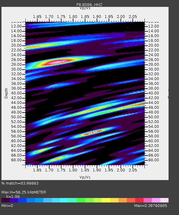
B086 santar086bcs2006, Anza, CA, USA - Earthquake Result Viewer
| Earthquake location: |
Peru-Brazil Border Region |
| Earthquake latitude/longitude: |
-10.1/-71.1 |
| Earthquake time(UTC): |
2015/11/24 (328) 22:50:53 GMT |
| Earthquake Depth: |
595 km |
| Earthquake Magnitude: |
5.9 MB |
| Earthquake Catalog/Contributor: |
NEIC PDE/NEIC COMCAT |
|
| Network: |
PB Plate Boundary Observatory Borehole Seismic Network |
| Station: |
B086 santar086bcs2006, Anza, CA, USA |
| Lat/Lon: |
33.56 N/116.53 W |
| Elevation: |
1392 m |
|
| Distance: |
61.3 deg |
| Az: |
317.252 deg |
| Baz: |
126.829 deg |
| Ray Param: |
0.05866002 |
| Estimated Moho Depth: |
56.25 km |
| Estimated Crust Vp/Vs: |
1.88 |
| Assumed Crust Vp: |
6.264 km/s |
| Estimated Crust Vs: |
3.332 km/s |
| Estimated Crust Poisson's Ratio: |
0.30 |
|
| Radial Match: |
83.96663 % |
| Radial Bump: |
400 |
| Transverse Match: |
62.193245 % |
| Transverse Bump: |
400 |
| SOD ConfigId: |
7422571 |
| Insert Time: |
2019-04-21 11:49:26.090 +0000 |
| GWidth: |
2.5 |
| Max Bumps: |
400 |
| Tol: |
0.001 |
|

Signal To Noise
| Channel | StoN | STA | LTA |
| PB:B086: :HHZ:20151124T22:59:40.249023Z | 14.77541 | 5.6117716E-7 | 3.798048E-8 |
| PB:B086: :HH1:20151124T22:59:40.249023Z | 7.989241 | 1.295301E-7 | 1.6213066E-8 |
| PB:B086: :HH2:20151124T22:59:40.249023Z | 7.699542 | 1.0301077E-7 | 1.3378818E-8 |
| Arrivals |
| Ps | 8.2 SECOND |
| PpPs | 25 SECOND |
| PsPs/PpSs | 33 SECOND |


