You are here: Home > Network List > PM - Portuguese National Seismic Network Stations List
> Station PFVI PM.PFVI > Earthquake Result Viewer
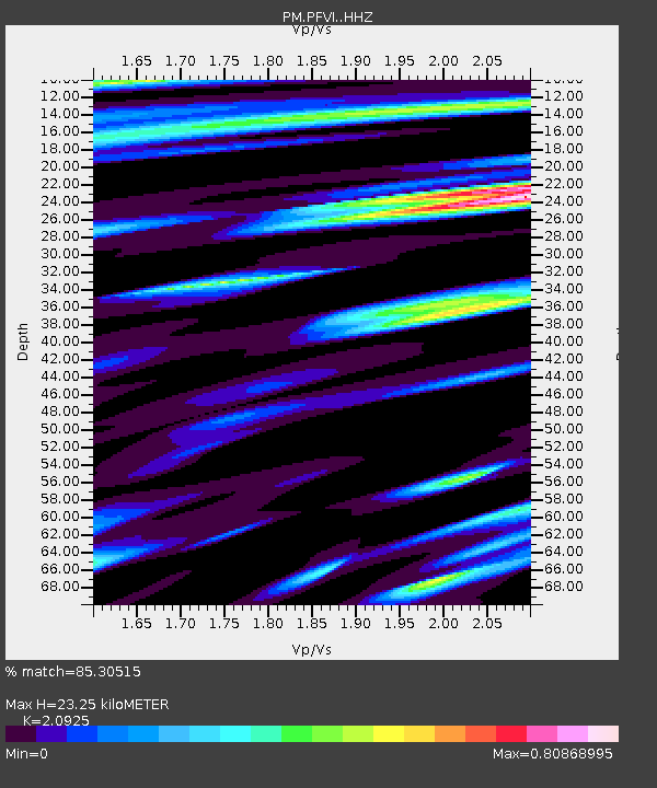
PFVI PM.PFVI - Earthquake Result Viewer
| Earthquake location: |
Peru-Brazil Border Region |
| Earthquake latitude/longitude: |
-10.1/-71.1 |
| Earthquake time(UTC): |
2015/11/24 (328) 22:50:53 GMT |
| Earthquake Depth: |
595 km |
| Earthquake Magnitude: |
5.9 MB |
| Earthquake Catalog/Contributor: |
NEIC PDE/NEIC COMCAT |
|
| Network: |
PM Portuguese National Seismic Network |
| Station: |
PFVI PM.PFVI |
| Lat/Lon: |
37.13 N/8.83 W |
| Elevation: |
189 m |
|
| Distance: |
74.8 deg |
| Az: |
47.121 deg |
| Baz: |
244.54 deg |
| Ray Param: |
0.050126266 |
| Estimated Moho Depth: |
23.25 km |
| Estimated Crust Vp/Vs: |
2.09 |
| Assumed Crust Vp: |
6.048 km/s |
| Estimated Crust Vs: |
2.89 km/s |
| Estimated Crust Poisson's Ratio: |
0.35 |
|
| Radial Match: |
85.30515 % |
| Radial Bump: |
400 |
| Transverse Match: |
84.16395 % |
| Transverse Bump: |
400 |
| SOD ConfigId: |
7422571 |
| Insert Time: |
2019-04-21 11:49:33.942 +0000 |
| GWidth: |
2.5 |
| Max Bumps: |
400 |
| Tol: |
0.001 |
|

Signal To Noise
| Channel | StoN | STA | LTA |
| PM:PFVI: :HHZ:20151124T23:01:01.500Z | 8.195103 | 4.224617E-5 | 5.155051E-6 |
| PM:PFVI: :HHN:20151124T23:01:01.500Z | 5.2000537 | 8.85084E-6 | 1.702067E-6 |
| PM:PFVI: :HHE:20151124T23:01:01.500Z | 5.9788594 | 1.430714E-5 | 2.3929547E-6 |
| Arrivals |
| Ps | 4.3 SECOND |
| PpPs | 12 SECOND |
| PsPs/PpSs | 16 SECOND |


