You are here: Home > Network List > PO - Portable Observatories for Lithospheric Analysis and Research Investigating Seis Stations List
> Station CHGQ Chibougamau, QC > Earthquake Result Viewer
CHGQ Chibougamau, QC - Earthquake Result Viewer
| Earthquake location: |
Peru-Brazil Border Region |
| Earthquake latitude/longitude: |
-10.1/-71.1 |
| Earthquake time(UTC): |
2015/11/24 (328) 22:50:53 GMT |
| Earthquake Depth: |
595 km |
| Earthquake Magnitude: |
5.9 MB |
| Earthquake Catalog/Contributor: |
NEIC PDE/NEIC COMCAT |
|
| Network: |
PO Portable Observatories for Lithospheric Analysis and Research Investigating Seis |
| Station: |
CHGQ Chibougamau, QC |
| Lat/Lon: |
49.91 N/74.37 W |
| Elevation: |
406 m |
|
| Distance: |
59.8 deg |
| Az: |
357.533 deg |
| Baz: |
176.241 deg |
| Ray Param: |
0.0595384 |
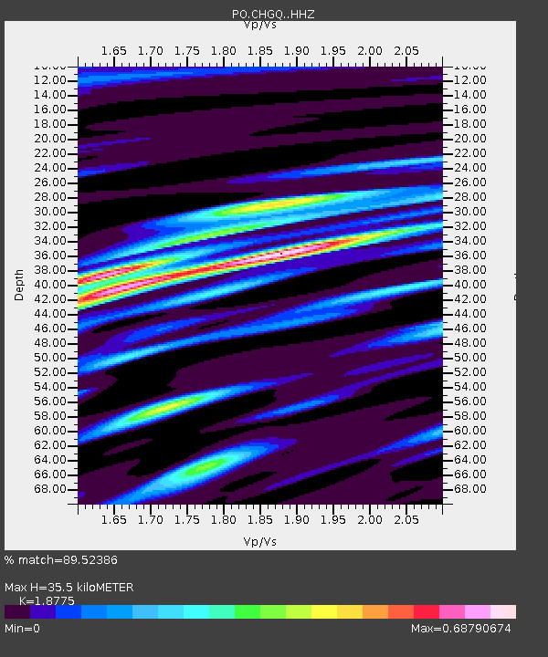
| Estimated Moho Depth: |
35.5 km |
| Estimated Crust Vp/Vs: |
1.88 |
| Assumed Crust Vp: |
6.61 km/s |
| Estimated Crust Vs: |
3.521 km/s |
| Estimated Crust Poisson's Ratio: |
0.30 |
|
| Radial Match: |
89.52386 % |
| Radial Bump: |
400 |
| Transverse Match: |
70.752495 % |
| Transverse Bump: |
400 |
| SOD ConfigId: |
7422571 |
| Insert Time: |
2019-04-21 11:49:37.681 +0000 |
| GWidth: |
2.5 |
| Max Bumps: |
400 |
| Tol: |
0.001 |
|

Signal To Noise
| Channel | StoN | STA | LTA |
| PO:CHGQ: :HHZ:20151124T22:59:30.609985Z | 15.3188305 | 3.26639E-5 | 2.132271E-6 |
| PO:CHGQ: :HHN:20151124T22:59:30.609985Z | 7.306903 | 1.3980397E-5 | 1.9133136E-6 |
| PO:CHGQ: :HHE:20151124T22:59:30.609985Z | 4.160122 | 3.7300722E-6 | 8.966257E-7 |
| Arrivals |
| Ps | 4.9 SECOND |
| PpPs | 15 SECOND |
| PsPs/PpSs | 20 SECOND |


