You are here: Home > Network List > TA - USArray Transportable Network (new EarthScope stations) Stations List
> Station I03D Drain, OR, USA > Earthquake Result Viewer
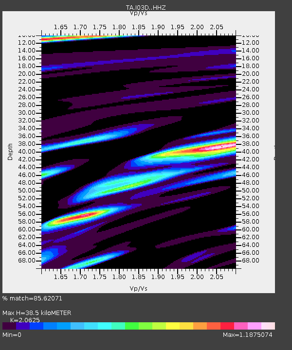
I03D Drain, OR, USA - Earthquake Result Viewer
| Earthquake location: |
Peru-Brazil Border Region |
| Earthquake latitude/longitude: |
-10.1/-71.1 |
| Earthquake time(UTC): |
2015/11/24 (328) 22:50:53 GMT |
| Earthquake Depth: |
595 km |
| Earthquake Magnitude: |
5.9 MB |
| Earthquake Catalog/Contributor: |
NEIC PDE/NEIC COMCAT |
|
| Network: |
TA USArray Transportable Network (new EarthScope stations) |
| Station: |
I03D Drain, OR, USA |
| Lat/Lon: |
43.70 N/123.35 W |
| Elevation: |
140 m |
|
| Distance: |
71.5 deg |
| Az: |
322.779 deg |
| Baz: |
124.795 deg |
| Ray Param: |
0.052242696 |
| Estimated Moho Depth: |
38.5 km |
| Estimated Crust Vp/Vs: |
2.06 |
| Assumed Crust Vp: |
6.522 km/s |
| Estimated Crust Vs: |
3.162 km/s |
| Estimated Crust Poisson's Ratio: |
0.35 |
|
| Radial Match: |
85.62071 % |
| Radial Bump: |
400 |
| Transverse Match: |
73.985085 % |
| Transverse Bump: |
400 |
| SOD ConfigId: |
7422571 |
| Insert Time: |
2019-04-21 11:50:32.122 +0000 |
| GWidth: |
2.5 |
| Max Bumps: |
400 |
| Tol: |
0.001 |
|

Signal To Noise
| Channel | StoN | STA | LTA |
| TA:I03D: :HHZ:20151124T23:00:43.119995Z | 11.792117 | 2.6364825E-5 | 2.235801E-6 |
| TA:I03D: :HHN:20151124T23:00:43.119995Z | 4.268063 | 5.985228E-6 | 1.402329E-6 |
| TA:I03D: :HHE:20151124T23:00:43.119995Z | 5.5384207 | 8.649513E-6 | 1.561729E-6 |
| Arrivals |
| Ps | 6.5 SECOND |
| PpPs | 18 SECOND |
| PsPs/PpSs | 24 SECOND |


