You are here: Home > Network List > GS - US Geological Survey Networks Stations List
> Station OK030 Cody Creek RV Park, Cushing, OK, USA > Earthquake Result Viewer
OK030 Cody Creek RV Park, Cushing, OK, USA - Earthquake Result Viewer
| Earthquake location: |
Near Coast Of Central Chile |
| Earthquake latitude/longitude: |
-36.3/-73.8 |
| Earthquake time(UTC): |
2015/06/20 (171) 02:10:06 GMT |
| Earthquake Depth: |
10 km |
| Earthquake Magnitude: |
6.4 MO |
| Earthquake Catalog/Contributor: |
NEIC PDE/NEIC ALERT |
|
| Network: |
GS US Geological Survey Networks |
| Station: |
OK030 Cody Creek RV Park, Cushing, OK, USA |
| Lat/Lon: |
35.93 N/96.78 W |
| Elevation: |
289 m |
|
| Distance: |
75.0 deg |
| Az: |
340.86 deg |
| Baz: |
160.961 deg |
| Ray Param: |
0.051959194 |
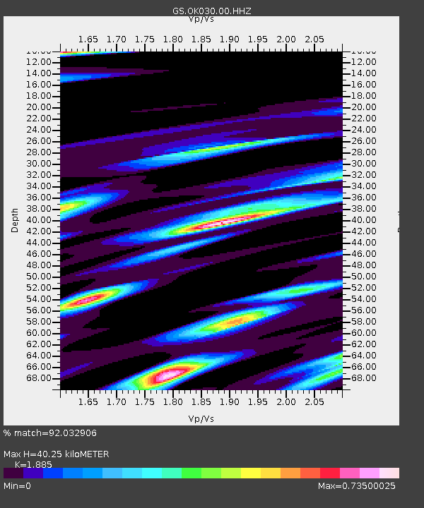
| Estimated Moho Depth: |
40.25 km |
| Estimated Crust Vp/Vs: |
1.88 |
| Assumed Crust Vp: |
6.426 km/s |
| Estimated Crust Vs: |
3.409 km/s |
| Estimated Crust Poisson's Ratio: |
0.30 |
|
| Radial Match: |
92.032906 % |
| Radial Bump: |
400 |
| Transverse Match: |
78.49801 % |
| Transverse Bump: |
400 |
| SOD ConfigId: |
976571 |
| Insert Time: |
2015-07-04 02:29:42.928 +0000 |
| GWidth: |
2.5 |
| Max Bumps: |
400 |
| Tol: |
0.001 |
|

Signal To Noise
| Channel | StoN | STA | LTA |
| GS:OK030:00:HHZ:20150620T02:21:16.524023Z | 7.273488 | 3.780627E-7 | 5.1978184E-8 |
| GS:OK030:00:HH1:20150620T02:21:16.524023Z | 2.8723903 | 2.183113E-7 | 7.600335E-8 |
| GS:OK030:00:HH2:20150620T02:21:16.524023Z | 3.0056875 | 3.3570257E-7 | 1.1168911E-7 |
| Arrivals |
| Ps | 5.7 SECOND |
| PpPs | 18 SECOND |
| PsPs/PpSs | 23 SECOND |


