You are here: Home > Network List > TA - USArray Transportable Network (new EarthScope stations) Stations List
> Station O03E Paynes Creek, CA, USA > Earthquake Result Viewer
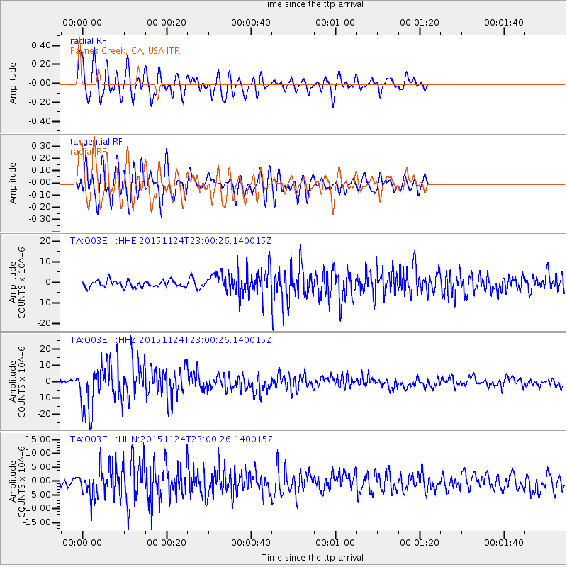
O03E Paynes Creek, CA, USA - Earthquake Result Viewer
*The percent match for this event was below the threshold and hence no stack was calculated.
| Earthquake location: |
Peru-Brazil Border Region |
| Earthquake latitude/longitude: |
-10.1/-71.1 |
| Earthquake time(UTC): |
2015/11/24 (328) 22:50:53 GMT |
| Earthquake Depth: |
595 km |
| Earthquake Magnitude: |
5.9 MB |
| Earthquake Catalog/Contributor: |
NEIC PDE/NEIC COMCAT |
|
| Network: |
TA USArray Transportable Network (new EarthScope stations) |
| Station: |
O03E Paynes Creek, CA, USA |
| Lat/Lon: |
40.29 N/121.80 W |
| Elevation: |
967 m |
|
| Distance: |
68.6 deg |
| Az: |
320.517 deg |
| Baz: |
125.055 deg |
| Ray Param: |
$rayparam |
*The percent match for this event was below the threshold and hence was not used in the summary stack. |
|
| Radial Match: |
73.53641 % |
| Radial Bump: |
400 |
| Transverse Match: |
67.44054 % |
| Transverse Bump: |
400 |
| SOD ConfigId: |
7422571 |
| Insert Time: |
2019-04-21 11:51:13.545 +0000 |
| GWidth: |
2.5 |
| Max Bumps: |
400 |
| Tol: |
0.001 |
|
Signal To Noise
| Channel | StoN | STA | LTA |
| TA:O03E: :HHZ:20151124T23:00:26.140015Z | 7.754692 | 1.4598089E-5 | 1.8824846E-6 |
| TA:O03E: :HHN:20151124T23:00:26.140015Z | 2.7694955 | 4.9949867E-6 | 1.8035727E-6 |
| TA:O03E: :HHE:20151124T23:00:26.140015Z | 2.6663964 | 4.244715E-6 | 1.5919294E-6 |
| Arrivals |
| Ps | |
| PpPs | |
| PsPs/PpSs | |


