You are here: Home > Network List > TA - USArray Transportable Network (new EarthScope stations) Stations List
> Station O48A Farmland, IN, USA > Earthquake Result Viewer
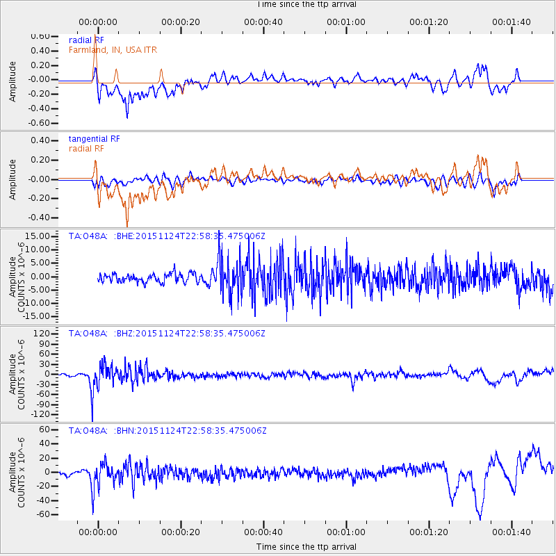
O48A Farmland, IN, USA - Earthquake Result Viewer
*The percent match for this event was below the threshold and hence no stack was calculated.
| Earthquake location: |
Peru-Brazil Border Region |
| Earthquake latitude/longitude: |
-10.1/-71.1 |
| Earthquake time(UTC): |
2015/11/24 (328) 22:50:53 GMT |
| Earthquake Depth: |
595 km |
| Earthquake Magnitude: |
5.9 MB |
| Earthquake Catalog/Contributor: |
NEIC PDE/NEIC COMCAT |
|
| Network: |
TA USArray Transportable Network (new EarthScope stations) |
| Station: |
O48A Farmland, IN, USA |
| Lat/Lon: |
40.26 N/85.16 W |
| Elevation: |
300 m |
|
| Distance: |
51.8 deg |
| Az: |
346.291 deg |
| Baz: |
162.246 deg |
| Ray Param: |
$rayparam |
*The percent match for this event was below the threshold and hence was not used in the summary stack. |
|
| Radial Match: |
58.887302 % |
| Radial Bump: |
400 |
| Transverse Match: |
62.324833 % |
| Transverse Bump: |
400 |
| SOD ConfigId: |
7422571 |
| Insert Time: |
2019-04-21 11:51:16.255 +0000 |
| GWidth: |
2.5 |
| Max Bumps: |
400 |
| Tol: |
0.001 |
|
Signal To Noise
| Channel | StoN | STA | LTA |
| TA:O48A: :BHZ:20151124T22:58:35.475006Z | 10.765425 | 2.683737E-5 | 2.4929225E-6 |
| TA:O48A: :BHN:20151124T22:58:35.475006Z | 6.7642646 | 1.33396625E-5 | 1.9720787E-6 |
| TA:O48A: :BHE:20151124T22:58:35.475006Z | 3.9361446 | 6.1872774E-6 | 1.5719132E-6 |
| Arrivals |
| Ps | |
| PpPs | |
| PsPs/PpSs | |


