You are here: Home > Network List > IC - New China Digital Seismograph Network Stations List
> Station KMI Kunming, Yunnan Province, China > Earthquake Result Viewer
KMI Kunming, Yunnan Province, China - Earthquake Result Viewer
| Earthquake location: |
Eastern Caucasus |
| Earthquake latitude/longitude: |
40.2/49.9 |
| Earthquake time(UTC): |
2000/11/25 (330) 18:09:11 GMT |
| Earthquake Depth: |
50 km |
| Earthquake Magnitude: |
5.8 MB, 6.3 MW |
| Earthquake Catalog/Contributor: |
WHDF/NEIC |
|
| Network: |
IC New China Digital Seismograph Network |
| Station: |
KMI Kunming, Yunnan Province, China |
| Lat/Lon: |
25.12 N/102.74 E |
| Elevation: |
1975 m |
|
| Distance: |
46.3 deg |
| Az: |
92.344 deg |
| Baz: |
302.469 deg |
| Ray Param: |
0.07062008 |
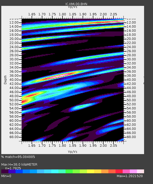
| Estimated Moho Depth: |
38.0 km |
| Estimated Crust Vp/Vs: |
1.78 |
| Assumed Crust Vp: |
6.247 km/s |
| Estimated Crust Vs: |
3.504 km/s |
| Estimated Crust Poisson's Ratio: |
0.27 |
|
| Radial Match: |
95.084885 % |
| Radial Bump: |
400 |
| Transverse Match: |
87.39013 % |
| Transverse Bump: |
400 |
| SOD ConfigId: |
3744 |
| Insert Time: |
2010-03-04 22:20:06.418 +0000 |
| GWidth: |
2.5 |
| Max Bumps: |
400 |
| Tol: |
0.001 |
|

Signal To Noise
| Channel | StoN | STA | LTA |
| IC:KMI:00:BHN:20001125T18:17:01.422014Z | 2.092372 | 1.4061321E-7 | 6.720278E-8 |
| IC:KMI:00:BHE:20001125T18:17:01.422014Z | 4.0661006 | 1.995108E-7 | 4.9066863E-8 |
| IC:KMI:00:BHZ:20001125T18:17:01.422014Z | 6.254385 | 4.0441205E-7 | 6.466056E-8 |
| Arrivals |
| Ps | 5.0 SECOND |
| PpPs | 16 SECOND |
| PsPs/PpSs | 21 SECOND |


