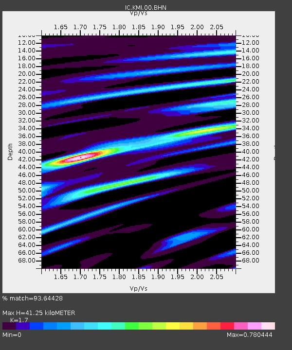
KMI Kunming, Yunnan Province, China - Earthquake Result Viewer
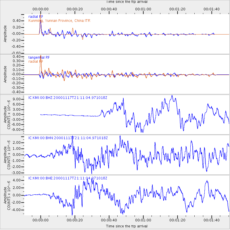
Earthquake location: New Britain Region, P.N.G.
Earthquake latitude/longitude: -5.5/151.8
Earthquake time(UTC): 2000/11/17 (322) 21:01:56 GMT
Earthquake Depth: 33 km
Earthquake Magnitude: 6.2 MB, 8.0 MS, 7.6 MW, 6.9 ME
Earthquake Catalog/Contributor: WHDF/NEIC
Network: IC New China Digital Seismograph Network
Station: KMI Kunming, Yunnan Province, China
Lat/Lon: 25.12 N/102.74 E
Elevation: 1975 m
Distance: 56.5 deg
Az: 304.86 deg
Baz: 115.699 deg
Ray Param: 0.06401636
Estimated Moho Depth: 41.25 km
Estimated Crust Vp/Vs: 1.70
Assumed Crust Vp: 6.247 km/s
Estimated Crust Vs: 3.674 km/s
Estimated Crust Poisson's Ratio: 0.24
Radial Match: 93.64428 %
Radial Bump: 400
Transverse Match: 71.15079 %
Transverse Bump: 400
SOD ConfigId: 3744
Insert Time: 2010-03-04 22:20:09.455 +0000
GWidth: 2.5
Max Bumps: 400
Tol: 0.001

Signal To Noise

ChannelStoNSTALTA
IC:KMI:00:BHN:20001117T21:11:04.971018Z1.1674651.7025128E-71.4582987E-7
IC:KMI:00:BHE:20001117T21:11:04.971018Z2.15242582.6722975E-71.2415283E-7
IC:KMI:00:BHZ:20001117T21:11:04.971018Z2.56876755.5591124E-72.1641165E-7
Arrivals
Ps4.9 SECOND
PpPs17 SECOND
PsPs/PpSs22 SECOND