You are here: Home > Network List > UW - Pacific Northwest Regional Seismic Network Stations List
> Station PHIN Phinny Hill Vineyards, Prosser, WA, USA > Earthquake Result Viewer
PHIN Phinny Hill Vineyards, Prosser, WA, USA - Earthquake Result Viewer
| Earthquake location: |
Peru-Brazil Border Region |
| Earthquake latitude/longitude: |
-10.1/-71.1 |
| Earthquake time(UTC): |
2015/11/24 (328) 22:50:53 GMT |
| Earthquake Depth: |
595 km |
| Earthquake Magnitude: |
5.9 MB |
| Earthquake Catalog/Contributor: |
NEIC PDE/NEIC COMCAT |
|
| Network: |
UW Pacific Northwest Regional Seismic Network |
| Station: |
PHIN Phinny Hill Vineyards, Prosser, WA, USA |
| Lat/Lon: |
45.90 N/119.93 W |
| Elevation: |
227 m |
|
| Distance: |
70.9 deg |
| Az: |
326.176 deg |
| Baz: |
128.293 deg |
| Ray Param: |
0.05265716 |
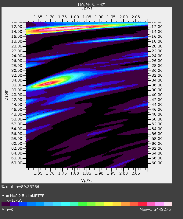
| Estimated Moho Depth: |
12.5 km |
| Estimated Crust Vp/Vs: |
1.75 |
| Assumed Crust Vp: |
6.571 km/s |
| Estimated Crust Vs: |
3.744 km/s |
| Estimated Crust Poisson's Ratio: |
0.26 |
|
| Radial Match: |
89.33236 % |
| Radial Bump: |
400 |
| Transverse Match: |
77.63024 % |
| Transverse Bump: |
400 |
| SOD ConfigId: |
7422571 |
| Insert Time: |
2019-04-21 11:52:23.260 +0000 |
| GWidth: |
2.5 |
| Max Bumps: |
400 |
| Tol: |
0.001 |
|

Signal To Noise
| Channel | StoN | STA | LTA |
| UW:PHIN: :HHZ:20151124T23:00:39.338013Z | 8.938232 | 2.8905788E-5 | 3.233949E-6 |
| UW:PHIN: :HHN:20151124T23:00:39.338013Z | 4.9097447 | 7.702366E-6 | 1.5687916E-6 |
| UW:PHIN: :HHE:20151124T23:00:39.338013Z | 5.7963195 | 1.2917533E-5 | 2.228575E-6 |
| Arrivals |
| Ps | 1.5 SECOND |
| PpPs | 5.1 SECOND |
| PsPs/PpSs | 6.5 SECOND |


