You are here: Home > Network List > XD14 - Illuminating the architecture of the greater Mount St. Helens magmatic systems f Stations List
> Station ME06 "Mount St Helens, WA" > Earthquake Result Viewer
ME06 "Mount St Helens, WA" - Earthquake Result Viewer
| Earthquake location: |
Peru-Brazil Border Region |
| Earthquake latitude/longitude: |
-10.1/-71.1 |
| Earthquake time(UTC): |
2015/11/24 (328) 22:50:53 GMT |
| Earthquake Depth: |
595 km |
| Earthquake Magnitude: |
5.9 MB |
| Earthquake Catalog/Contributor: |
NEIC PDE/NEIC COMCAT |
|
| Network: |
XD Illuminating the architecture of the greater Mount St. Helens magmatic systems f |
| Station: |
ME06 "Mount St Helens, WA" |
| Lat/Lon: |
46.46 N/122.20 W |
| Elevation: |
643 m |
|
| Distance: |
72.5 deg |
| Az: |
325.643 deg |
| Baz: |
126.494 deg |
| Ray Param: |
0.051643725 |
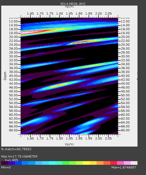
| Estimated Moho Depth: |
17.75 km |
| Estimated Crust Vp/Vs: |
1.61 |
| Assumed Crust Vp: |
6.566 km/s |
| Estimated Crust Vs: |
4.091 km/s |
| Estimated Crust Poisson's Ratio: |
0.18 |
|
| Radial Match: |
80.79552 % |
| Radial Bump: |
400 |
| Transverse Match: |
66.577065 % |
| Transverse Bump: |
400 |
| SOD ConfigId: |
7422571 |
| Insert Time: |
2019-04-21 11:53:01.489 +0000 |
| GWidth: |
2.5 |
| Max Bumps: |
400 |
| Tol: |
0.001 |
|

Signal To Noise
| Channel | StoN | STA | LTA |
| XD:ME06: :BHZ:20151124T23:00:48.570007Z | 9.128856 | 2.1835074E-5 | 2.391874E-6 |
| XD:ME06: :BHN:20151124T23:00:48.570007Z | 2.7590914 | 5.1370653E-6 | 1.8618683E-6 |
| XD:ME06: :BHE:20151124T23:00:48.570007Z | 3.6595473 | 7.508552E-6 | 2.0517707E-6 |
| Arrivals |
| Ps | 1.7 SECOND |
| PpPs | 6.8 SECOND |
| PsPs/PpSs | 8.5 SECOND |


