You are here: Home > Network List > IC - New China Digital Seismograph Network Stations List
> Station KMI Kunming, Yunnan Province, China > Earthquake Result Viewer
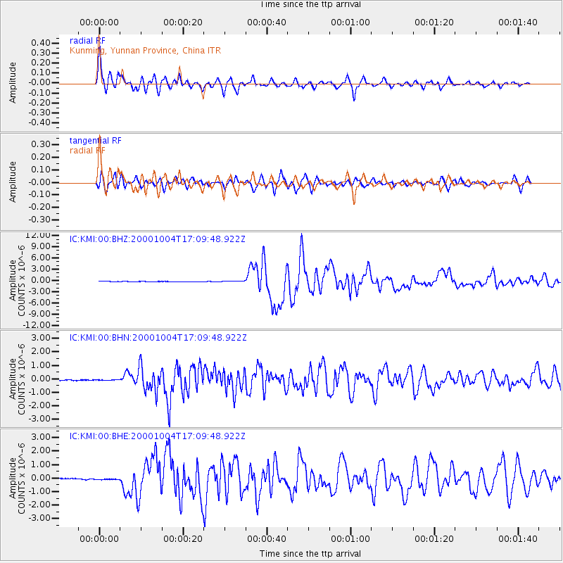
KMI Kunming, Yunnan Province, China - Earthquake Result Viewer
| Earthquake location: |
Vanuatu Islands |
| Earthquake latitude/longitude: |
-15.4/166.9 |
| Earthquake time(UTC): |
2000/10/04 (278) 16:58:44 GMT |
| Earthquake Depth: |
23 km |
| Earthquake Magnitude: |
6.1 MB, 6.9 MS, 6.8 MW, 6.5 ME |
| Earthquake Catalog/Contributor: |
WHDF/NEIC |
|
| Network: |
IC New China Digital Seismograph Network |
| Station: |
KMI Kunming, Yunnan Province, China |
| Lat/Lon: |
25.12 N/102.74 E |
| Elevation: |
1975 m |
|
| Distance: |
74.4 deg |
| Az: |
302.088 deg |
| Baz: |
115.656 deg |
| Ray Param: |
0.052349962 |
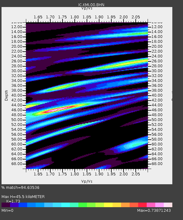
| Estimated Moho Depth: |
45.5 km |
| Estimated Crust Vp/Vs: |
1.73 |
| Assumed Crust Vp: |
6.247 km/s |
| Estimated Crust Vs: |
3.611 km/s |
| Estimated Crust Poisson's Ratio: |
0.25 |
|
| Radial Match: |
94.63536 % |
| Radial Bump: |
400 |
| Transverse Match: |
88.401474 % |
| Transverse Bump: |
400 |
| SOD ConfigId: |
3744 |
| Insert Time: |
2010-03-04 22:20:49.657 +0000 |
| GWidth: |
2.5 |
| Max Bumps: |
400 |
| Tol: |
0.001 |
|
Signal To Noise
| Channel | StoN | STA | LTA |
| IC:KMI:00:BHN:20001004T17:09:48.922Z | 0.67856133 | 2.3302347E-8 | 3.434081E-8 |
| IC:KMI:00:BHE:20001004T17:09:48.922Z | 1.1340573 | 3.935138E-8 | 3.4699642E-8 |
| IC:KMI:00:BHZ:20001004T17:09:48.922Z | 2.3737533 | 9.419708E-8 | 3.9682757E-8 |
| Arrivals |
| Ps | 5.5 SECOND |
| PpPs | 19 SECOND |
| PsPs/PpSs | 25 SECOND |


