You are here: Home > Network List > YT07 - POLENET Stations List
> Station ALYS ALYS > Earthquake Result Viewer
ALYS ALYS - Earthquake Result Viewer
| Earthquake location: |
Peru-Brazil Border Region |
| Earthquake latitude/longitude: |
-10.1/-71.1 |
| Earthquake time(UTC): |
2015/11/24 (328) 22:50:53 GMT |
| Earthquake Depth: |
595 km |
| Earthquake Magnitude: |
5.9 MB |
| Earthquake Catalog/Contributor: |
NEIC PDE/NEIC COMCAT |
|
| Network: |
YT POLENET |
| Station: |
ALYS ALYS |
| Lat/Lon: |
84.35 S/23.73 W |
| Elevation: |
2084 m |
|
| Distance: |
76.1 deg |
| Az: |
175.698 deg |
| Baz: |
311.768 deg |
| Ray Param: |
0.04927765 |
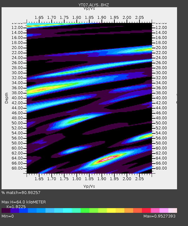
| Estimated Moho Depth: |
64.0 km |
| Estimated Crust Vp/Vs: |
1.92 |
| Assumed Crust Vp: |
6.356 km/s |
| Estimated Crust Vs: |
3.306 km/s |
| Estimated Crust Poisson's Ratio: |
0.31 |
|
| Radial Match: |
90.98257 % |
| Radial Bump: |
400 |
| Transverse Match: |
88.272896 % |
| Transverse Bump: |
400 |
| SOD ConfigId: |
7422571 |
| Insert Time: |
2019-04-21 11:54:20.432 +0000 |
| GWidth: |
2.5 |
| Max Bumps: |
400 |
| Tol: |
0.001 |
|

Signal To Noise
| Channel | StoN | STA | LTA |
| YT:ALYS: :BHZ:20151124T23:01:09.325012Z | 16.522694 | 5.3460048E-5 | 3.2355526E-6 |
| YT:ALYS: :BHN:20151124T23:01:09.325012Z | 3.5409675 | 7.635954E-6 | 2.1564597E-6 |
| YT:ALYS: :BHE:20151124T23:01:09.325012Z | 5.225375 | 1.0796865E-5 | 2.0662374E-6 |
| Arrivals |
| Ps | 9.5 SECOND |
| PpPs | 29 SECOND |
| PsPs/PpSs | 38 SECOND |


