You are here: Home > Network List > TA - USArray Transportable Network (new EarthScope stations) Stations List
> Station A21K Barrow, AK, USA > Earthquake Result Viewer
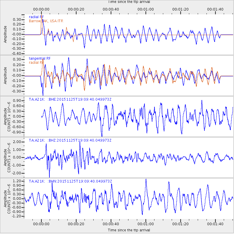
A21K Barrow, AK, USA - Earthquake Result Viewer
*The percent match for this event was below the threshold and hence no stack was calculated.
| Earthquake location: |
Northern Molucca Sea |
| Earthquake latitude/longitude: |
1.4/126.4 |
| Earthquake time(UTC): |
2015/11/25 (329) 18:57:42 GMT |
| Earthquake Depth: |
39 km |
| Earthquake Magnitude: |
5.7 MB |
| Earthquake Catalog/Contributor: |
NEIC PDE/NEIC COMCAT |
|
| Network: |
TA USArray Transportable Network (new EarthScope stations) |
| Station: |
A21K Barrow, AK, USA |
| Lat/Lon: |
71.32 N/156.62 W |
| Elevation: |
577 m |
|
| Distance: |
84.5 deg |
| Az: |
18.384 deg |
| Baz: |
258.131 deg |
| Ray Param: |
$rayparam |
*The percent match for this event was below the threshold and hence was not used in the summary stack. |
|
| Radial Match: |
53.041573 % |
| Radial Bump: |
400 |
| Transverse Match: |
60.764866 % |
| Transverse Bump: |
400 |
| SOD ConfigId: |
7422571 |
| Insert Time: |
2019-04-21 11:57:44.427 +0000 |
| GWidth: |
2.5 |
| Max Bumps: |
400 |
| Tol: |
0.001 |
|
Signal To Noise
| Channel | StoN | STA | LTA |
| TA:A21K: :BHZ:20151125T19:09:40.049973Z | 5.5159063 | 8.249651E-7 | 1.4956112E-7 |
| TA:A21K: :BHN:20151125T19:09:40.049973Z | 1.4190276 | 3.7416376E-7 | 2.6367618E-7 |
| TA:A21K: :BHE:20151125T19:09:40.049973Z | 1.1832356 | 3.8469608E-7 | 3.2512213E-7 |
| Arrivals |
| Ps | |
| PpPs | |
| PsPs/PpSs | |


