You are here: Home > Network List > IC - New China Digital Seismograph Network Stations List
> Station KMI Kunming, Yunnan Province, China > Earthquake Result Viewer
KMI Kunming, Yunnan Province, China - Earthquake Result Viewer

| Earthquake location: |
Mariana Islands |
| Earthquake latitude/longitude: |
13.8/144.8 |
| Earthquake time(UTC): |
2000/02/26 (057) 08:11:48 GMT |
| Earthquake Depth: |
132 km |
| Earthquake Magnitude: |
6.0 MB, 5.4 MS, 6.2 MW, 6.2 MW |
| Earthquake Catalog/Contributor: |
WHDF/NEIC |
|
| Network: |
IC New China Digital Seismograph Network |
| Station: |
KMI Kunming, Yunnan Province, China |
| Lat/Lon: |
25.12 N/102.74 E |
| Elevation: |
1975 m |
|
| Distance: |
41.1 deg |
| Az: |
292.44 deg |
| Baz: |
97.864 deg |
| Ray Param: |
0.07353978 |
| Estimated Moho Depth: |
16.25 km |
| Estimated Crust Vp/Vs: |
1.86 |
| Assumed Crust Vp: |
6.247 km/s |
| Estimated Crust Vs: |
3.367 km/s |
| Estimated Crust Poisson's Ratio: |
0.30 |
|
| Radial Match: |
91.75111 % |
| Radial Bump: |
400 |
| Transverse Match: |
77.171005 % |
| Transverse Bump: |
400 |
| SOD ConfigId: |
3744 |
| Insert Time: |
2010-03-04 22:21:49.665 +0000 |
| GWidth: |
2.5 |
| Max Bumps: |
400 |
| Tol: |
0.001 |
|
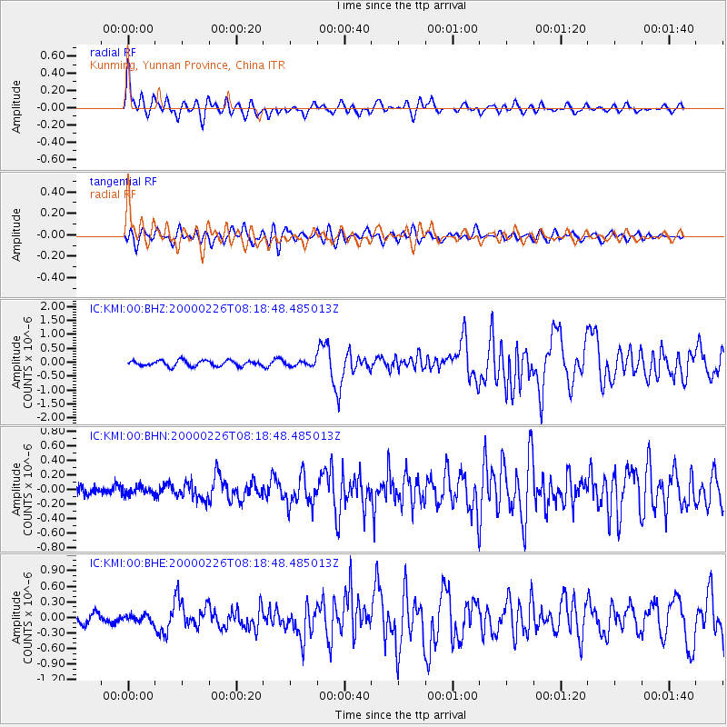
Signal To Noise
| Channel | StoN | STA | LTA |
| IC:KMI:00:BHN:20000226T08:18:48.485013Z | 0.81599694 | 5.598906E-8 | 6.86143E-8 |
| IC:KMI:00:BHE:20000226T08:18:48.485013Z | 0.83559495 | 7.017799E-8 | 8.398565E-8 |
| IC:KMI:00:BHZ:20000226T08:18:48.485013Z | 0.89426786 | 8.899156E-8 | 9.9513315E-8 |
| Arrivals |
| Ps | 2.4 SECOND |
| PpPs | 7.0 SECOND |
| PsPs/PpSs | 9.4 SECOND |


