You are here: Home > Network List > 6E - Wabash Valley Seismic Zone Stations List
> Station WB45 KY, USA > Earthquake Result Viewer
WB45 KY, USA - Earthquake Result Viewer
| Earthquake location: |
Peru-Brazil Border Region |
| Earthquake latitude/longitude: |
-9.2/-71.3 |
| Earthquake time(UTC): |
2015/11/26 (330) 05:45:18 GMT |
| Earthquake Depth: |
604 km |
| Earthquake Magnitude: |
6.4 MWP |
| Earthquake Catalog/Contributor: |
NEIC PDE/NEIC COMCAT |
|
| Network: |
6E Wabash Valley Seismic Zone |
| Station: |
WB45 KY, USA |
| Lat/Lon: |
37.72 N/86.52 W |
| Elevation: |
176 m |
|
| Distance: |
48.8 deg |
| Az: |
343.914 deg |
| Baz: |
159.821 deg |
| Ray Param: |
0.06621094 |
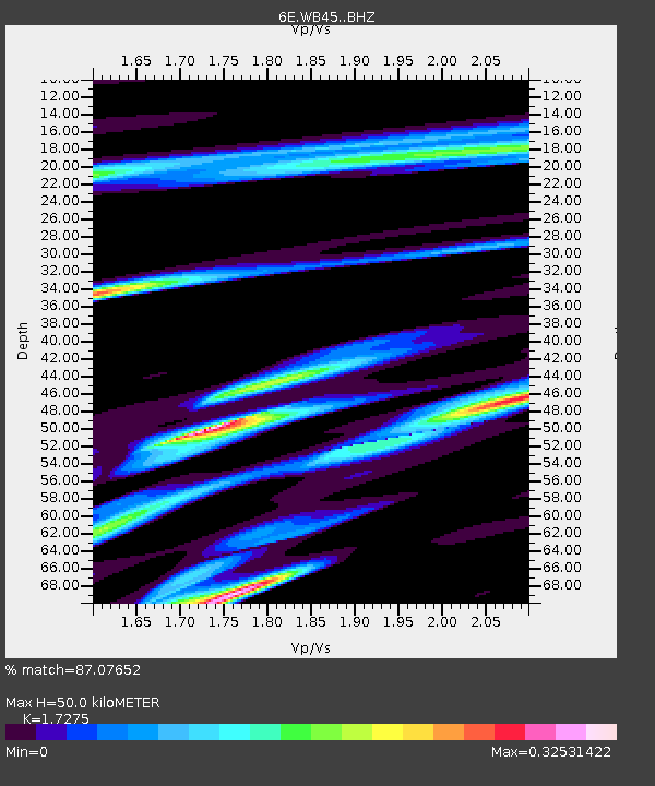
| Estimated Moho Depth: |
50.0 km |
| Estimated Crust Vp/Vs: |
1.73 |
| Assumed Crust Vp: |
6.444 km/s |
| Estimated Crust Vs: |
3.73 km/s |
| Estimated Crust Poisson's Ratio: |
0.25 |
|
| Radial Match: |
87.07652 % |
| Radial Bump: |
395 |
| Transverse Match: |
71.08196 % |
| Transverse Bump: |
400 |
| SOD ConfigId: |
7422571 |
| Insert Time: |
2019-04-21 11:59:34.003 +0000 |
| GWidth: |
2.5 |
| Max Bumps: |
400 |
| Tol: |
0.001 |
|

Signal To Noise
| Channel | StoN | STA | LTA |
| 6E:WB45: :BHZ:20151126T05:52:39.335009Z | 25.944893 | 5.6504286E-6 | 2.1778578E-7 |
| 6E:WB45: :BHN:20151126T05:52:39.335009Z | 11.439648 | 2.4497213E-6 | 2.1414306E-7 |
| 6E:WB45: :BHE:20151126T05:52:39.335009Z | 4.634426 | 8.861239E-7 | 1.9120468E-7 |
| Arrivals |
| Ps | 6.0 SECOND |
| PpPs | 20 SECOND |
| PsPs/PpSs | 26 SECOND |


