You are here: Home > Network List > 7A - Mid-Atlantic Geophysical Integrative Collaboration Stations List
> Station BDEG Charles Lake, Virginia USA > Earthquake Result Viewer
BDEG Charles Lake, Virginia USA - Earthquake Result Viewer
| Earthquake location: |
Peru-Brazil Border Region |
| Earthquake latitude/longitude: |
-9.2/-71.3 |
| Earthquake time(UTC): |
2015/11/26 (330) 05:45:18 GMT |
| Earthquake Depth: |
604 km |
| Earthquake Magnitude: |
6.4 MWP |
| Earthquake Catalog/Contributor: |
NEIC PDE/NEIC COMCAT |
|
| Network: |
7A Mid-Atlantic Geophysical Integrative Collaboration |
| Station: |
BDEG Charles Lake, Virginia USA |
| Lat/Lon: |
37.33 N/77.21 W |
| Elevation: |
-21.0 m |
|
| Distance: |
46.6 deg |
| Az: |
353.488 deg |
| Baz: |
171.926 deg |
| Ray Param: |
0.06754087 |
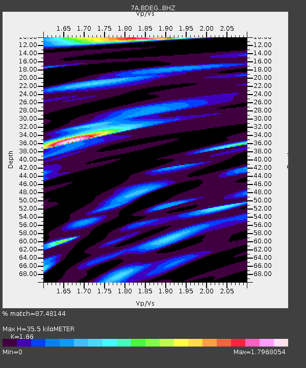
| Estimated Moho Depth: |
35.5 km |
| Estimated Crust Vp/Vs: |
1.66 |
| Assumed Crust Vp: |
6.565 km/s |
| Estimated Crust Vs: |
3.955 km/s |
| Estimated Crust Poisson's Ratio: |
0.22 |
|
| Radial Match: |
87.48144 % |
| Radial Bump: |
400 |
| Transverse Match: |
53.382725 % |
| Transverse Bump: |
400 |
| SOD ConfigId: |
7422571 |
| Insert Time: |
2019-04-21 11:59:35.472 +0000 |
| GWidth: |
2.5 |
| Max Bumps: |
400 |
| Tol: |
0.001 |
|

Signal To Noise
| Channel | StoN | STA | LTA |
| 7A:BDEG: :BHZ:20151126T05:52:23.045Z | 33.32892 | 4.9961736E-6 | 1.4990506E-7 |
| 7A:BDEG: :BHN:20151126T05:52:23.045Z | 16.730606 | 4.3856558E-6 | 2.6213368E-7 |
| 7A:BDEG: :BHE:20151126T05:52:23.045Z | 2.891725 | 7.475082E-7 | 2.5849906E-7 |
| Arrivals |
| Ps | 3.8 SECOND |
| PpPs | 13 SECOND |
| PsPs/PpSs | 17 SECOND |


