You are here: Home > Network List > 7A - Mid-Atlantic Geophysical Integrative Collaboration Stations List
> Station INTX Elkton, Virginia USA > Earthquake Result Viewer
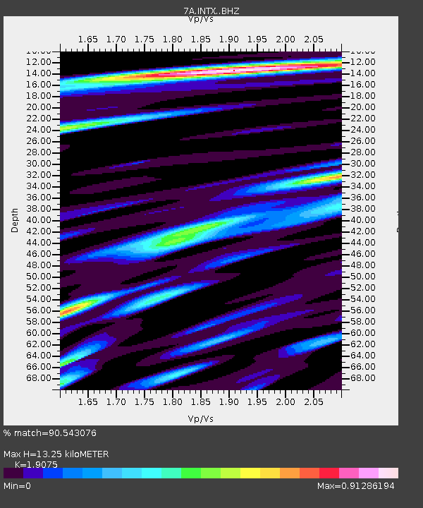
INTX Elkton, Virginia USA - Earthquake Result Viewer
| Earthquake location: |
Peru-Brazil Border Region |
| Earthquake latitude/longitude: |
-9.2/-71.3 |
| Earthquake time(UTC): |
2015/11/26 (330) 05:45:18 GMT |
| Earthquake Depth: |
604 km |
| Earthquake Magnitude: |
6.4 MWP |
| Earthquake Catalog/Contributor: |
NEIC PDE/NEIC COMCAT |
|
| Network: |
7A Mid-Atlantic Geophysical Integrative Collaboration |
| Station: |
INTX Elkton, Virginia USA |
| Lat/Lon: |
38.40 N/78.59 W |
| Elevation: |
320 m |
|
| Distance: |
47.9 deg |
| Az: |
352.248 deg |
| Baz: |
170.242 deg |
| Ray Param: |
0.06679902 |
| Estimated Moho Depth: |
13.25 km |
| Estimated Crust Vp/Vs: |
1.91 |
| Assumed Crust Vp: |
6.159 km/s |
| Estimated Crust Vs: |
3.229 km/s |
| Estimated Crust Poisson's Ratio: |
0.31 |
|
| Radial Match: |
90.543076 % |
| Radial Bump: |
400 |
| Transverse Match: |
65.610245 % |
| Transverse Bump: |
400 |
| SOD ConfigId: |
7422571 |
| Insert Time: |
2019-04-21 11:59:40.291 +0000 |
| GWidth: |
2.5 |
| Max Bumps: |
400 |
| Tol: |
0.001 |
|

Signal To Noise
| Channel | StoN | STA | LTA |
| 7A:INTX: :BHZ:20151126T05:52:32.210009Z | 18.156706 | 7.051351E-6 | 3.883607E-7 |
| 7A:INTX: :BHN:20151126T05:52:32.210009Z | 19.72224 | 4.694033E-6 | 2.3800709E-7 |
| 7A:INTX: :BHE:20151126T05:52:32.210009Z | 8.974153 | 2.106418E-6 | 2.3472053E-7 |
| Arrivals |
| Ps | 2.0 SECOND |
| PpPs | 6.0 SECOND |
| PsPs/PpSs | 8.0 SECOND |


