You are here: Home > Network List > 7A - Mid-Atlantic Geophysical Integrative Collaboration Stations List
> Station WTMN Standardsville, Virginia USA > Earthquake Result Viewer
WTMN Standardsville, Virginia USA - Earthquake Result Viewer
| Earthquake location: |
Peru-Brazil Border Region |
| Earthquake latitude/longitude: |
-9.2/-71.3 |
| Earthquake time(UTC): |
2015/11/26 (330) 05:45:18 GMT |
| Earthquake Depth: |
604 km |
| Earthquake Magnitude: |
6.4 MWP |
| Earthquake Catalog/Contributor: |
NEIC PDE/NEIC COMCAT |
|
| Network: |
7A Mid-Atlantic Geophysical Integrative Collaboration |
| Station: |
WTMN Standardsville, Virginia USA |
| Lat/Lon: |
38.30 N/78.48 W |
| Elevation: |
178 m |
|
| Distance: |
47.8 deg |
| Az: |
352.338 deg |
| Baz: |
170.37 deg |
| Ray Param: |
0.06687111 |
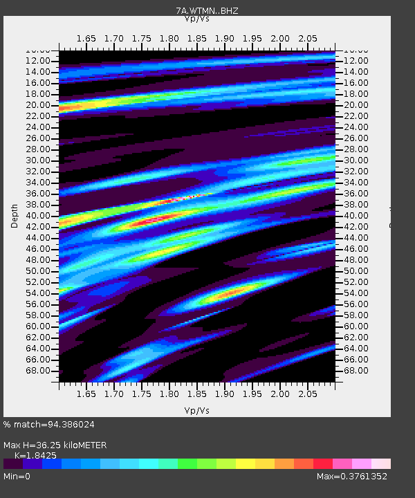
| Estimated Moho Depth: |
36.25 km |
| Estimated Crust Vp/Vs: |
1.84 |
| Assumed Crust Vp: |
6.159 km/s |
| Estimated Crust Vs: |
3.343 km/s |
| Estimated Crust Poisson's Ratio: |
0.29 |
|
| Radial Match: |
94.386024 % |
| Radial Bump: |
246 |
| Transverse Match: |
72.757744 % |
| Transverse Bump: |
400 |
| SOD ConfigId: |
7422571 |
| Insert Time: |
2019-04-21 11:59:50.468 +0000 |
| GWidth: |
2.5 |
| Max Bumps: |
400 |
| Tol: |
0.001 |
|

Signal To Noise
| Channel | StoN | STA | LTA |
| 7A:WTMN: :BHZ:20151126T05:52:31.300005Z | 29.74701 | 6.5588597E-6 | 2.2048805E-7 |
| 7A:WTMN: :BHN:20151126T05:52:31.300005Z | 24.27599 | 3.6194547E-6 | 1.4909607E-7 |
| 7A:WTMN: :BHE:20151126T05:52:31.300005Z | 1.9395181 | 3.4107674E-7 | 1.7585644E-7 |
| Arrivals |
| Ps | 5.2 SECOND |
| PpPs | 16 SECOND |
| PsPs/PpSs | 21 SECOND |


