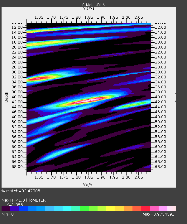
KMI Kunming, Yunnan Province, China - Earthquake Result Viewer

Earthquake location: Andreanof Islands, Aleutian Is.
Earthquake latitude/longitude: 51.6/-177.7
Earthquake time(UTC): 1999/03/20 (079) 10:47:45 GMT
Earthquake Depth: 33 km
Earthquake Magnitude: 6.3 MB, 6.8 MS, 6.9 MW, 6.8 ME
Earthquake Catalog/Contributor: WHDF/NEIC
Network: IC New China Digital Seismograph Network
Station: KMI Kunming, Yunnan Province, China
Lat/Lon: 25.12 N/102.74 E
Elevation: 1975 m
Distance: 64.4 deg
Az: 278.638 deg
Baz: 42.878 deg
Ray Param: 0.05889659
Estimated Moho Depth: 41.0 km
Estimated Crust Vp/Vs: 1.86
Assumed Crust Vp: 6.247 km/s
Estimated Crust Vs: 3.367 km/s
Estimated Crust Poisson's Ratio: 0.30
Radial Match: 93.47305 %
Radial Bump: 400
Transverse Match: 85.80192 %
Transverse Bump: 400
SOD ConfigId: 4480
Insert Time: 2010-03-04 22:22:14.985 +0000
GWidth: 2.5
Max Bumps: 400
Tol: 0.001

Signal To Noise

ChannelStoNSTALTA
IC:KMI: :BHN:19990320T10:57:47.877021Z62.3931435.685682E-69.112671E-8
IC:KMI: :BHE:19990320T10:57:47.877021Z19.8000621.614191E-68.152454E-8
IC:KMI: :BHZ:19990320T10:57:47.877021Z12.9820211.1873638E-69.146216E-8
Arrivals
Ps5.8 SECOND
PpPs18 SECOND
PsPs/PpSs24 SECOND