You are here: Home > Network List > CI - Caltech Regional Seismic Network Stations List
> Station BAR Barrett, Tecate, CA, USA > Earthquake Result Viewer
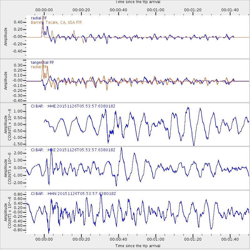
BAR Barrett, Tecate, CA, USA - Earthquake Result Viewer
*The percent match for this event was below the threshold and hence no stack was calculated.
| Earthquake location: |
Peru-Brazil Border Region |
| Earthquake latitude/longitude: |
-9.2/-71.3 |
| Earthquake time(UTC): |
2015/11/26 (330) 05:45:18 GMT |
| Earthquake Depth: |
604 km |
| Earthquake Magnitude: |
6.4 MWP |
| Earthquake Catalog/Contributor: |
NEIC PDE/NEIC COMCAT |
|
| Network: |
CI Caltech Regional Seismic Network |
| Station: |
BAR Barrett, Tecate, CA, USA |
| Lat/Lon: |
32.68 N/116.67 W |
| Elevation: |
521 m |
|
| Distance: |
60.1 deg |
| Az: |
316.139 deg |
| Baz: |
125.793 deg |
| Ray Param: |
$rayparam |
*The percent match for this event was below the threshold and hence was not used in the summary stack. |
|
| Radial Match: |
67.819305 % |
| Radial Bump: |
295 |
| Transverse Match: |
71.184265 % |
| Transverse Bump: |
344 |
| SOD ConfigId: |
7422571 |
| Insert Time: |
2019-04-21 12:01:59.526 +0000 |
| GWidth: |
2.5 |
| Max Bumps: |
400 |
| Tol: |
0.001 |
|
Signal To Noise
| Channel | StoN | STA | LTA |
| CI:BAR: :HHZ:20151126T05:53:57.638018Z | 2.7919154 | 1.2783835E-6 | 4.5788764E-7 |
| CI:BAR: :HHN:20151126T05:53:57.638018Z | 1.5754652 | 3.9321864E-7 | 2.495889E-7 |
| CI:BAR: :HHE:20151126T05:53:57.638018Z | 1.8847598 | 7.5335953E-7 | 3.9971115E-7 |
| Arrivals |
| Ps | |
| PpPs | |
| PsPs/PpSs | |


