You are here: Home > Network List > IC - New China Digital Seismograph Network Stations List
> Station KMI Kunming, Yunnan Province, China > Earthquake Result Viewer
KMI Kunming, Yunnan Province, China - Earthquake Result Viewer

| Earthquake location: |
Banda Sea |
| Earthquake latitude/longitude: |
-7.5/127.7 |
| Earthquake time(UTC): |
2001/09/18 (261) 02:19:30 GMT |
| Earthquake Depth: |
132 km |
| Earthquake Magnitude: |
5.6 MB, 5.1 MS, 6.0 MW, 6.0 MW |
| Earthquake Catalog/Contributor: |
WHDF/NEIC |
|
| Network: |
IC New China Digital Seismograph Network |
| Station: |
KMI Kunming, Yunnan Province, China |
| Lat/Lon: |
25.12 N/102.74 E |
| Elevation: |
1975 m |
|
| Distance: |
40.6 deg |
| Az: |
323.897 deg |
| Baz: |
139.87 deg |
| Ray Param: |
0.073857196 |
| Estimated Moho Depth: |
14.25 km |
| Estimated Crust Vp/Vs: |
2.00 |
| Assumed Crust Vp: |
6.247 km/s |
| Estimated Crust Vs: |
3.131 km/s |
| Estimated Crust Poisson's Ratio: |
0.33 |
|
| Radial Match: |
92.375244 % |
| Radial Bump: |
400 |
| Transverse Match: |
84.05374 % |
| Transverse Bump: |
400 |
| SOD ConfigId: |
20082 |
| Insert Time: |
2010-03-04 22:22:38.548 +0000 |
| GWidth: |
2.5 |
| Max Bumps: |
400 |
| Tol: |
0.001 |
|
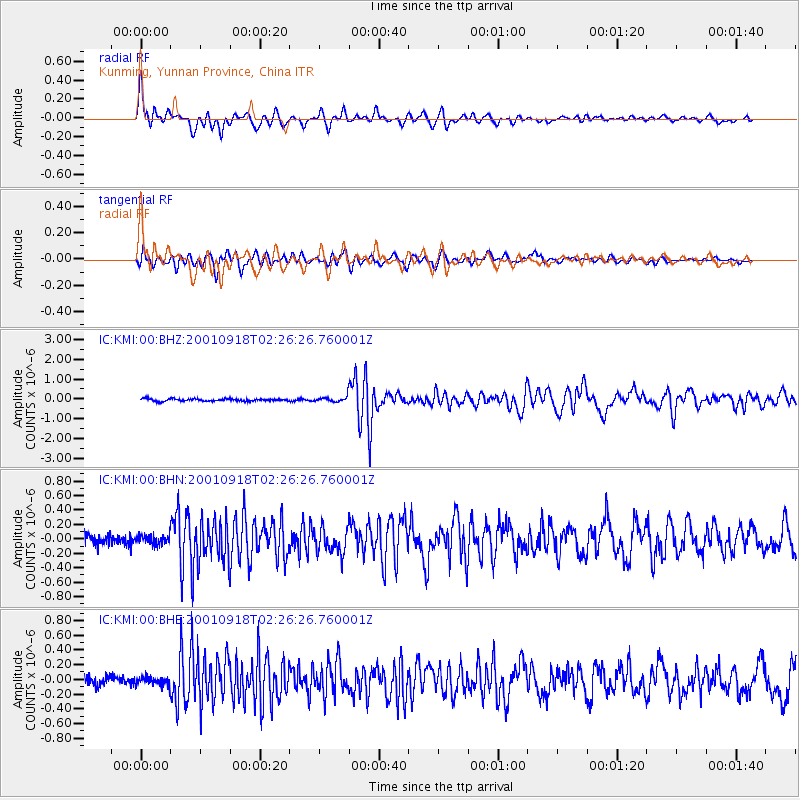
Signal To Noise
| Channel | StoN | STA | LTA |
| IC:KMI:00:BHN:20010918T02:26:26.760001Z | 0.91206574 | 6.2331104E-8 | 6.8340576E-8 |
| IC:KMI:00:BHE:20010918T02:26:26.760001Z | 0.992739 | 5.522607E-8 | 5.5629997E-8 |
| IC:KMI:00:BHZ:20010918T02:26:26.760001Z | 2.194898 | 1.3231525E-7 | 6.02831E-8 |
| Arrivals |
| Ps | 2.4 SECOND |
| PpPs | 6.5 SECOND |
| PsPs/PpSs | 8.9 SECOND |


