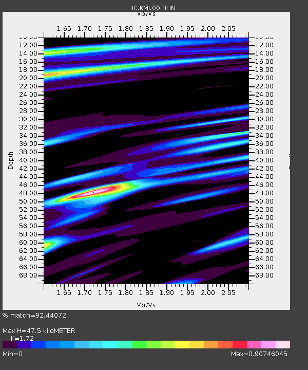
KMI Kunming, Yunnan Province, China - Earthquake Result Viewer
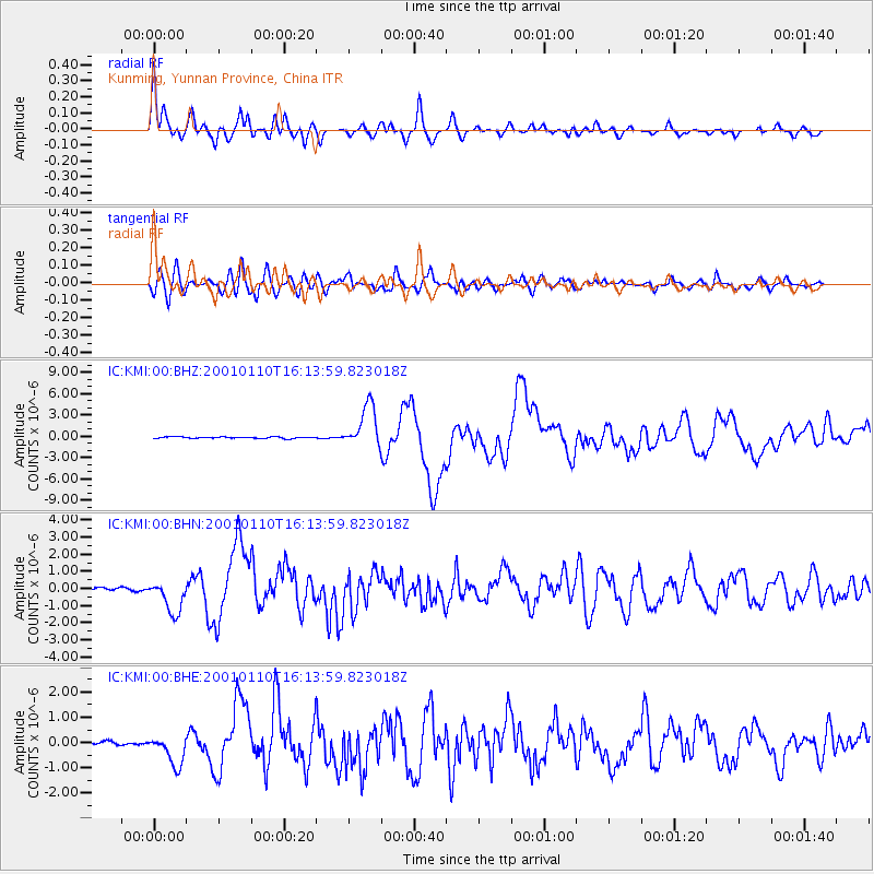
Earthquake location: Kodiak Island Region, Alaska
Earthquake latitude/longitude: 57.1/-153.2
Earthquake time(UTC): 2001/01/10 (010) 16:02:44 GMT
Earthquake Depth: 33 km
Earthquake Magnitude: 6.2 MB, 6.8 MS, 7.1 MW, 6.8 ML
Earthquake Catalog/Contributor: WHDF/NEIC
Network: IC New China Digital Seismograph Network
Station: KMI Kunming, Yunnan Province, China
Lat/Lon: 25.12 N/102.74 E
Elevation: 1975 m
Distance: 76.5 deg
Az: 295.259 deg
Baz: 33.011 deg
Ray Param: 0.050910525
Estimated Moho Depth: 47.5 km
Estimated Crust Vp/Vs: 1.72
Assumed Crust Vp: 6.247 km/s
Estimated Crust Vs: 3.632 km/s
Estimated Crust Poisson's Ratio: 0.24
Radial Match: 92.44072 %
Radial Bump: 400
Transverse Match: 86.96846 %
Transverse Bump: 400
SOD ConfigId: 3744
Insert Time: 2010-03-04 22:23:04.592 +0000
GWidth: 2.5
Max Bumps: 400
Tol: 0.001

Signal To Noise

ChannelStoNSTALTA
IC:KMI:00:BHN:20010110T16:13:59.823018Z13.172279.736866E-77.391942E-8
IC:KMI:00:BHE:20010110T16:13:59.823018Z9.2620545.998396E-76.476313E-8
IC:KMI:00:BHZ:20010110T16:13:59.823018Z28.6388053.0211295E-61.0549076E-7
Arrivals
Ps5.6 SECOND
PpPs20 SECOND
PsPs/PpSs26 SECOND