You are here: Home > Network List > GE - GEOFON Stations List
> Station SNAA GEOFON/AWI Station Sanae, Antarctica > Earthquake Result Viewer
SNAA GEOFON/AWI Station Sanae, Antarctica - Earthquake Result Viewer
| Earthquake location: |
Peru-Brazil Border Region |
| Earthquake latitude/longitude: |
-9.2/-71.3 |
| Earthquake time(UTC): |
2015/11/26 (330) 05:45:18 GMT |
| Earthquake Depth: |
604 km |
| Earthquake Magnitude: |
6.4 MWP |
| Earthquake Catalog/Contributor: |
NEIC PDE/NEIC COMCAT |
|
| Network: |
GE GEOFON |
| Station: |
SNAA GEOFON/AWI Station Sanae, Antarctica |
| Lat/Lon: |
71.67 S/2.84 W |
| Elevation: |
846 m |
|
| Distance: |
74.6 deg |
| Az: |
162.228 deg |
| Baz: |
287.748 deg |
| Ray Param: |
0.05025261 |
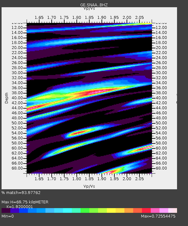
| Estimated Moho Depth: |
69.75 km |
| Estimated Crust Vp/Vs: |
1.92 |
| Assumed Crust Vp: |
6.43 km/s |
| Estimated Crust Vs: |
3.349 km/s |
| Estimated Crust Poisson's Ratio: |
0.31 |
|
| Radial Match: |
93.97762 % |
| Radial Bump: |
360 |
| Transverse Match: |
90.65216 % |
| Transverse Bump: |
400 |
| SOD ConfigId: |
7422571 |
| Insert Time: |
2019-04-21 12:04:29.999 +0000 |
| GWidth: |
2.5 |
| Max Bumps: |
400 |
| Tol: |
0.001 |
|
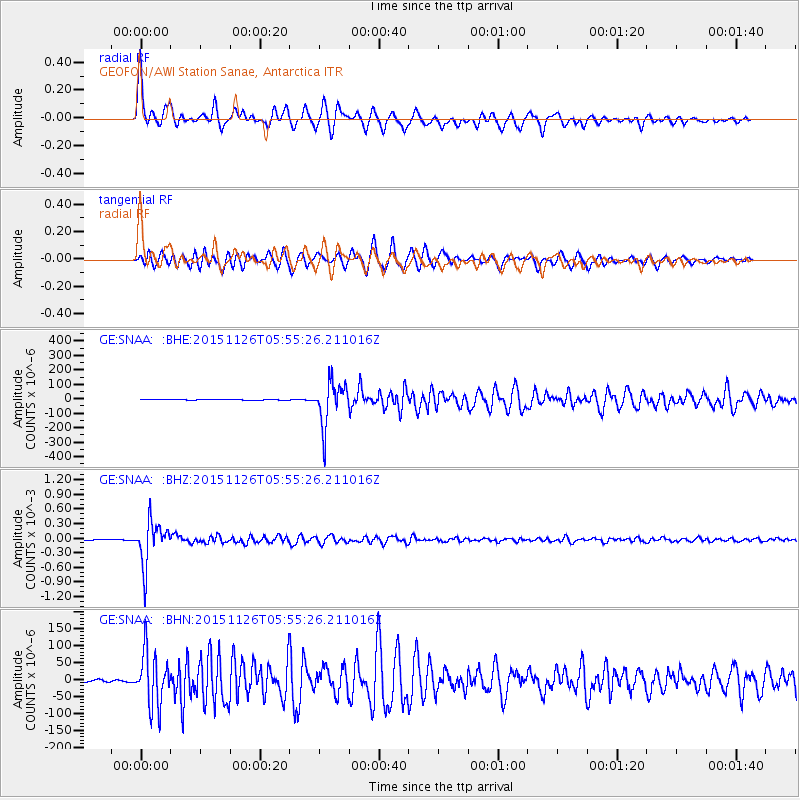
Signal To Noise
| Channel | StoN | STA | LTA |
| GE:SNAA: :BHZ:20151126T05:55:26.211016Z | 98.2778 | 4.4460886E-4 | 4.524001E-6 |
| GE:SNAA: :BHN:20151126T05:55:26.211016Z | 29.147924 | 7.754084E-5 | 2.6602527E-6 |
| GE:SNAA: :BHE:20151126T05:55:26.211016Z | 54.22808 | 1.4945507E-4 | 2.7560457E-6 |
| Arrivals |
| Ps | 10 SECOND |
| PpPs | 31 SECOND |
| PsPs/PpSs | 41 SECOND |


