You are here: Home > Network List > GT - Global Telemetered Seismograph Network (USAF/USGS) Stations List
> Station PLCA Paso Flores, Argentina > Earthquake Result Viewer
PLCA Paso Flores, Argentina - Earthquake Result Viewer
| Earthquake location: |
Peru-Brazil Border Region |
| Earthquake latitude/longitude: |
-9.2/-71.3 |
| Earthquake time(UTC): |
2015/11/26 (330) 05:45:18 GMT |
| Earthquake Depth: |
604 km |
| Earthquake Magnitude: |
6.4 MWP |
| Earthquake Catalog/Contributor: |
NEIC PDE/NEIC COMCAT |
|
| Network: |
GT Global Telemetered Seismograph Network (USAF/USGS) |
| Station: |
PLCA Paso Flores, Argentina |
| Lat/Lon: |
40.73 S/70.55 W |
| Elevation: |
1050 m |
|
| Distance: |
31.4 deg |
| Az: |
178.95 deg |
| Baz: |
358.636 deg |
| Ray Param: |
0.07625899 |
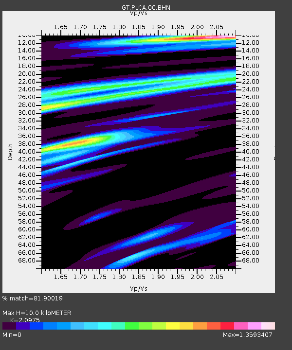
| Estimated Moho Depth: |
10.0 km |
| Estimated Crust Vp/Vs: |
2.10 |
| Assumed Crust Vp: |
6.597 km/s |
| Estimated Crust Vs: |
3.145 km/s |
| Estimated Crust Poisson's Ratio: |
0.35 |
|
| Radial Match: |
81.90019 % |
| Radial Bump: |
391 |
| Transverse Match: |
70.490555 % |
| Transverse Bump: |
400 |
| SOD ConfigId: |
7422571 |
| Insert Time: |
2019-04-21 12:04:38.457 +0000 |
| GWidth: |
2.5 |
| Max Bumps: |
400 |
| Tol: |
0.001 |
|

Signal To Noise
| Channel | StoN | STA | LTA |
| GT:PLCA:00:BHZ:20151126T05:50:21.699999Z | 8.083985 | 5.4808143E-6 | 6.779842E-7 |
| GT:PLCA:00:BHN:20151126T05:50:21.699999Z | 10.347834 | 3.6693673E-6 | 3.5460243E-7 |
| GT:PLCA:00:BHE:20151126T05:50:21.699999Z | 2.105164 | 9.868726E-7 | 4.687865E-7 |
| Arrivals |
| Ps | 1.8 SECOND |
| PpPs | 4.4 SECOND |
| PsPs/PpSs | 6.2 SECOND |


