You are here: Home > Network List > II - Global Seismograph Network (GSN - IRIS/IDA) Stations List
> Station CMLA Cha de Macela, Sao Miguel Island, Azores > Earthquake Result Viewer
CMLA Cha de Macela, Sao Miguel Island, Azores - Earthquake Result Viewer
| Earthquake location: |
Peru-Brazil Border Region |
| Earthquake latitude/longitude: |
-9.2/-71.3 |
| Earthquake time(UTC): |
2015/11/26 (330) 05:45:18 GMT |
| Earthquake Depth: |
604 km |
| Earthquake Magnitude: |
6.4 MWP |
| Earthquake Catalog/Contributor: |
NEIC PDE/NEIC COMCAT |
|
| Network: |
II Global Seismograph Network (GSN - IRIS/IDA) |
| Station: |
CMLA Cha de Macela, Sao Miguel Island, Azores |
| Lat/Lon: |
37.76 N/25.52 W |
| Elevation: |
429 m |
|
| Distance: |
63.3 deg |
| Az: |
39.437 deg |
| Baz: |
232.305 deg |
| Ray Param: |
0.057323642 |
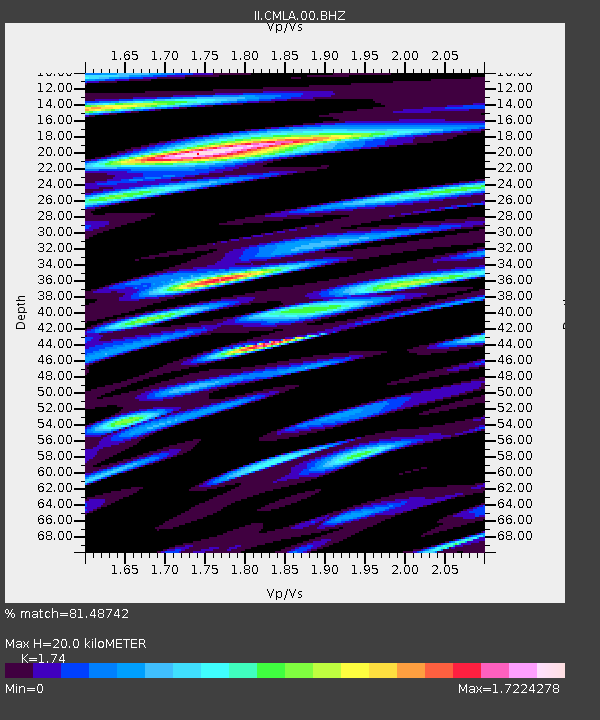
| Estimated Moho Depth: |
20.0 km |
| Estimated Crust Vp/Vs: |
1.74 |
| Assumed Crust Vp: |
4.802 km/s |
| Estimated Crust Vs: |
2.76 km/s |
| Estimated Crust Poisson's Ratio: |
0.25 |
|
| Radial Match: |
81.48742 % |
| Radial Bump: |
400 |
| Transverse Match: |
78.93668 % |
| Transverse Bump: |
400 |
| SOD ConfigId: |
7422571 |
| Insert Time: |
2019-04-21 12:04:44.235 +0000 |
| GWidth: |
2.5 |
| Max Bumps: |
400 |
| Tol: |
0.001 |
|

Signal To Noise
| Channel | StoN | STA | LTA |
| II:CMLA:00:BHZ:20151126T05:54:18.618975Z | 12.420106 | 9.964369E-6 | 8.022773E-7 |
| II:CMLA:00:BH1:20151126T05:54:18.618975Z | 3.5065732 | 4.7438957E-6 | 1.352858E-6 |
| II:CMLA:00:BH2:20151126T05:54:18.618975Z | 4.374798 | 6.269362E-6 | 1.4330633E-6 |
| Arrivals |
| Ps | 3.2 SECOND |
| PpPs | 11 SECOND |
| PsPs/PpSs | 14 SECOND |


