You are here: Home > Network List > LD - Lamont-Doherty Cooperative Seismographic Network Stations List
> Station BRNJ Basking Ridge, New Jersey > Earthquake Result Viewer
BRNJ Basking Ridge, New Jersey - Earthquake Result Viewer
| Earthquake location: |
Peru-Brazil Border Region |
| Earthquake latitude/longitude: |
-9.2/-71.3 |
| Earthquake time(UTC): |
2015/11/26 (330) 05:45:18 GMT |
| Earthquake Depth: |
604 km |
| Earthquake Magnitude: |
6.4 MWP |
| Earthquake Catalog/Contributor: |
NEIC PDE/NEIC COMCAT |
|
| Network: |
LD Lamont-Doherty Cooperative Seismographic Network |
| Station: |
BRNJ Basking Ridge, New Jersey |
| Lat/Lon: |
40.68 N/74.57 W |
| Elevation: |
50 m |
|
| Distance: |
49.8 deg |
| Az: |
356.716 deg |
| Baz: |
175.736 deg |
| Ray Param: |
0.06564408 |
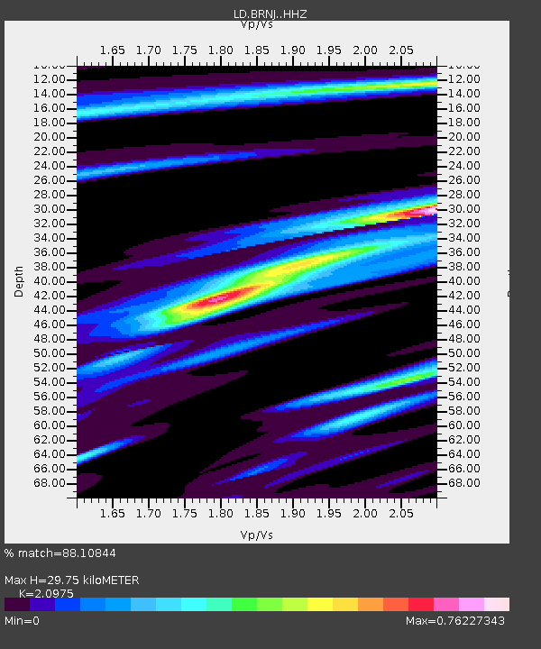
| Estimated Moho Depth: |
29.75 km |
| Estimated Crust Vp/Vs: |
2.10 |
| Assumed Crust Vp: |
6.283 km/s |
| Estimated Crust Vs: |
2.996 km/s |
| Estimated Crust Poisson's Ratio: |
0.35 |
|
| Radial Match: |
88.10844 % |
| Radial Bump: |
238 |
| Transverse Match: |
53.41631 % |
| Transverse Bump: |
394 |
| SOD ConfigId: |
7422571 |
| Insert Time: |
2019-04-21 12:05:18.653 +0000 |
| GWidth: |
2.5 |
| Max Bumps: |
400 |
| Tol: |
0.001 |
|

Signal To Noise
| Channel | StoN | STA | LTA |
| LD:BRNJ: :HHZ:20151126T05:52:45.990007Z | 16.759312 | 4.376608E-6 | 2.6114486E-7 |
| LD:BRNJ: :HHN:20151126T05:52:45.990007Z | 8.608111 | 2.5116083E-6 | 2.9177227E-7 |
| LD:BRNJ: :HHE:20151126T05:52:45.990007Z | 3.4050827 | 5.512884E-7 | 1.6190162E-7 |
| Arrivals |
| Ps | 5.4 SECOND |
| PpPs | 14 SECOND |
| PsPs/PpSs | 19 SECOND |


