You are here: Home > Network List > IC - New China Digital Seismograph Network Stations List
> Station KMI Kunming, Yunnan Province, China > Earthquake Result Viewer
KMI Kunming, Yunnan Province, China - Earthquake Result Viewer
| Earthquake location: |
Java, Indonesia |
| Earthquake latitude/longitude: |
-7.9/110.2 |
| Earthquake time(UTC): |
2001/05/25 (145) 05:06:10 GMT |
| Earthquake Depth: |
143 km |
| Earthquake Magnitude: |
5.8 MB, 6.3 MW, 6.3 MW |
| Earthquake Catalog/Contributor: |
WHDF/NEIC |
|
| Network: |
IC New China Digital Seismograph Network |
| Station: |
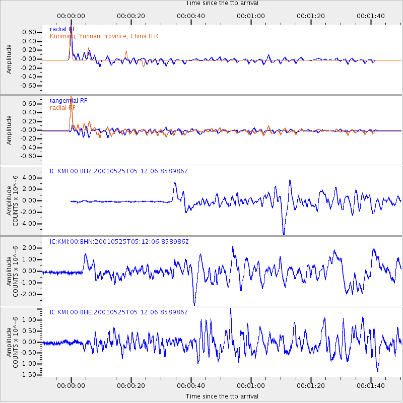
KMI Kunming, Yunnan Province, China |
| Lat/Lon: |
25.12 N/102.74 E |
| Elevation: |
1975 m |
|
| Distance: |
33.6 deg |
| Az: |
347.75 deg |
| Baz: |
166.592 deg |
| Ray Param: |
0.077699825 |
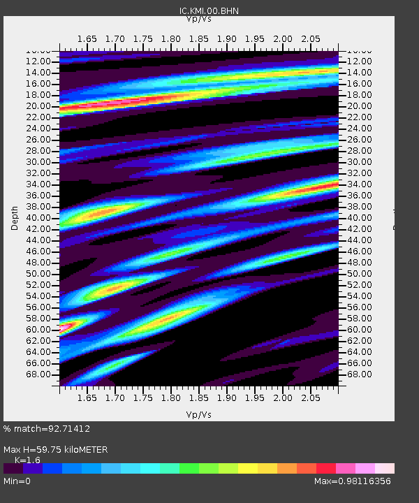
| Estimated Moho Depth: |
59.75 km |
| Estimated Crust Vp/Vs: |
1.60 |
| Assumed Crust Vp: |
6.247 km/s |
| Estimated Crust Vs: |
3.904 km/s |
| Estimated Crust Poisson's Ratio: |
0.18 |
|
| Radial Match: |
92.71412 % |
| Radial Bump: |
400 |
| Transverse Match: |
85.07933 % |
| Transverse Bump: |
400 |
| SOD ConfigId: |
4714 |
| Insert Time: |
2010-03-04 22:23:24.545 +0000 |
| GWidth: |
2.5 |
| Max Bumps: |
400 |
| Tol: |
0.001 |
|
Signal To Noise
| Channel | StoN | STA | LTA |
| IC:KMI:00:BHN:20010525T05:12:06.858986Z | 7.6576796 | 4.5937182E-7 | 5.998839E-8 |
| IC:KMI:00:BHE:20010525T05:12:06.858986Z | 2.2023213 | 1.14493545E-7 | 5.1987666E-8 |
| IC:KMI:00:BHZ:20010525T05:12:06.858986Z | 16.32535 | 1.0752078E-6 | 6.5861244E-8 |
| Arrivals |
| Ps | 6.2 SECOND |
| PpPs | 23 SECOND |
| PsPs/PpSs | 29 SECOND |


