You are here: Home > Network List > LD - Lamont-Doherty Cooperative Seismographic Network Stations List
> Station LUPA Lehigh University, PA > Earthquake Result Viewer
LUPA Lehigh University, PA - Earthquake Result Viewer
| Earthquake location: |
Peru-Brazil Border Region |
| Earthquake latitude/longitude: |
-9.2/-71.3 |
| Earthquake time(UTC): |
2015/11/26 (330) 05:45:18 GMT |
| Earthquake Depth: |
604 km |
| Earthquake Magnitude: |
6.4 MWP |
| Earthquake Catalog/Contributor: |
NEIC PDE/NEIC COMCAT |
|
| Network: |
LD Lamont-Doherty Cooperative Seismographic Network |
| Station: |
LUPA Lehigh University, PA |
| Lat/Lon: |
40.60 N/75.37 W |
| Elevation: |
236 m |
|
| Distance: |
49.7 deg |
| Az: |
355.907 deg |
| Baz: |
174.69 deg |
| Ray Param: |
0.06566321 |
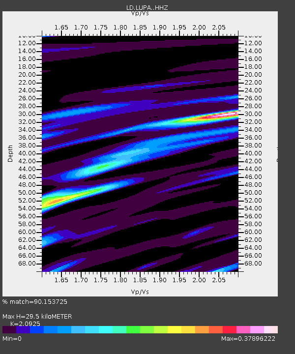
| Estimated Moho Depth: |
29.5 km |
| Estimated Crust Vp/Vs: |
2.09 |
| Assumed Crust Vp: |
6.283 km/s |
| Estimated Crust Vs: |
3.003 km/s |
| Estimated Crust Poisson's Ratio: |
0.35 |
|
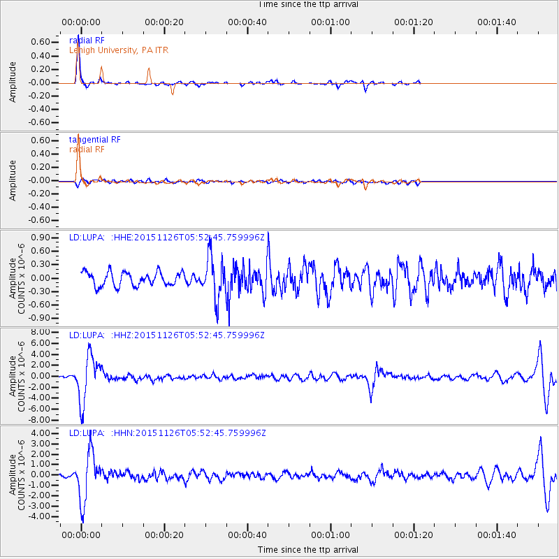
| Radial Match: |
90.153725 % |
| Radial Bump: |
190 |
| Transverse Match: |
54.603474 % |
| Transverse Bump: |
400 |
| SOD ConfigId: |
7422571 |
| Insert Time: |
2019-04-21 12:05:27.941 +0000 |
| GWidth: |
2.5 |
| Max Bumps: |
400 |
| Tol: |
0.001 |
|
Signal To Noise
| Channel | StoN | STA | LTA |
| LD:LUPA: :HHZ:20151126T05:52:45.759996Z | 23.320312 | 4.2642077E-6 | 1.8285381E-7 |
| LD:LUPA: :HHN:20151126T05:52:45.759996Z | 10.243363 | 2.3727844E-6 | 2.3164115E-7 |
| LD:LUPA: :HHE:20151126T05:52:45.759996Z | 3.5406048 | 5.308501E-7 | 1.4993205E-7 |
| Arrivals |
| Ps | 5.4 SECOND |
| PpPs | 14 SECOND |
| PsPs/PpSs | 19 SECOND |


