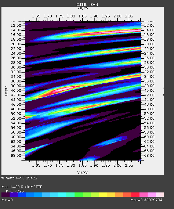
KMI Kunming, Yunnan Province, China - Earthquake Result Viewer
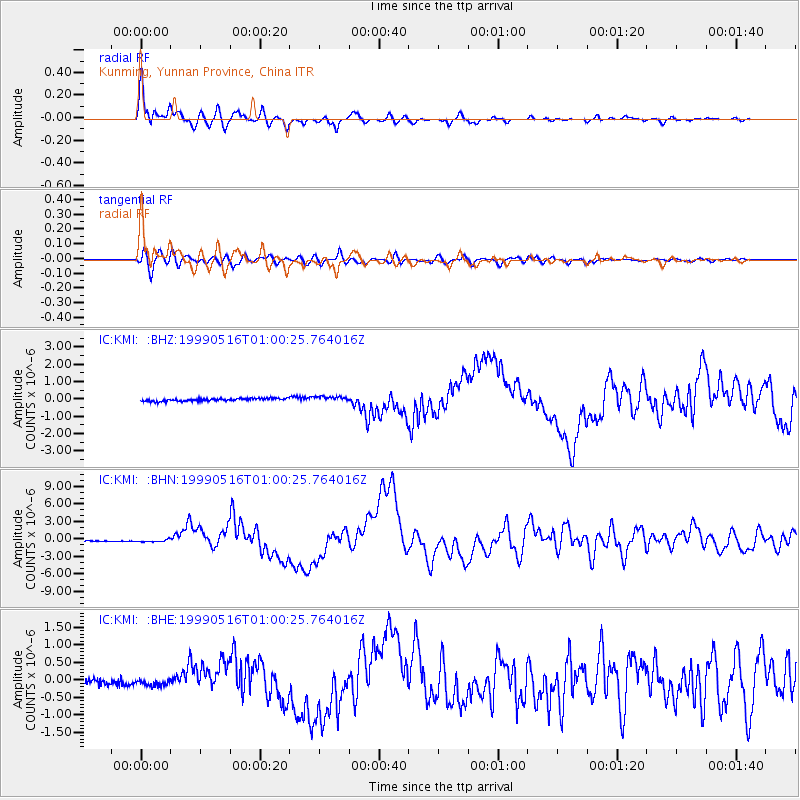
Earthquake location: New Britain Region, P.N.G.
Earthquake latitude/longitude: -4.8/152.5
Earthquake time(UTC): 1999/05/16 (136) 00:51:20 GMT
Earthquake Depth: 74 km
Earthquake Magnitude: 6.0 MB, 7.0 MS, 7.1 MW, 6.3 ME
Earthquake Catalog/Contributor: WHDF/NEIC
Network: IC New China Digital Seismograph Network
Station: KMI Kunming, Yunnan Province, China
Lat/Lon: 25.12 N/102.74 E
Elevation: 1975 m
Distance: 56.7 deg
Az: 304.134 deg
Baz: 114.492 deg
Ray Param: 0.06376686
Estimated Moho Depth: 39.0 km
Estimated Crust Vp/Vs: 1.77
Assumed Crust Vp: 6.247 km/s
Estimated Crust Vs: 3.524 km/s
Estimated Crust Poisson's Ratio: 0.27
Radial Match: 96.85422 %
Radial Bump: 400
Transverse Match: 86.582886 %
Transverse Bump: 400
SOD ConfigId: 4480
Insert Time: 2010-03-04 22:23:59.938 +0000
GWidth: 2.5
Max Bumps: 400
Tol: 0.001

Signal To Noise

ChannelStoNSTALTA
IC:KMI: :BHN:19990516T01:00:25.764016Z2.0896962.2110922E-71.05809285E-7
IC:KMI: :BHE:19990516T01:00:25.764016Z1.27233369.68344E-87.610771E-8
IC:KMI: :BHZ:19990516T01:00:25.764016Z1.9571781.5374023E-77.855199E-8
Arrivals
Ps5.1 SECOND
PpPs17 SECOND
PsPs/PpSs22 SECOND