You are here: Home > Network List > N4 - Central and EAstern US Network Stations List
> Station P53A Whipple, OH, USA > Earthquake Result Viewer
P53A Whipple, OH, USA - Earthquake Result Viewer
| Earthquake location: |
Peru-Brazil Border Region |
| Earthquake latitude/longitude: |
-9.2/-71.3 |
| Earthquake time(UTC): |
2015/11/26 (330) 05:45:18 GMT |
| Earthquake Depth: |
604 km |
| Earthquake Magnitude: |
6.4 MWP |
| Earthquake Catalog/Contributor: |
NEIC PDE/NEIC COMCAT |
|
| Network: |
N4 Central and EAstern US Network |
| Station: |
P53A Whipple, OH, USA |
| Lat/Lon: |
39.49 N/81.39 W |
| Elevation: |
270 m |
|
| Distance: |
49.4 deg |
| Az: |
349.679 deg |
| Baz: |
166.788 deg |
| Ray Param: |
0.06588014 |
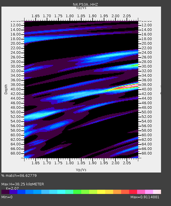
| Estimated Moho Depth: |
38.25 km |
| Estimated Crust Vp/Vs: |
2.07 |
| Assumed Crust Vp: |
6.207 km/s |
| Estimated Crust Vs: |
2.999 km/s |
| Estimated Crust Poisson's Ratio: |
0.35 |
|
| Radial Match: |
86.62779 % |
| Radial Bump: |
323 |
| Transverse Match: |
67.580795 % |
| Transverse Bump: |
400 |
| SOD ConfigId: |
7422571 |
| Insert Time: |
2019-04-21 12:07:09.028 +0000 |
| GWidth: |
2.5 |
| Max Bumps: |
400 |
| Tol: |
0.001 |
|

Signal To Noise
| Channel | StoN | STA | LTA |
| N4:P53A: :HHZ:20151126T05:52:43.210009Z | 32.97801 | 9.936942E-6 | 3.0132026E-7 |
| N4:P53A: :HHN:20151126T05:52:43.210009Z | 21.71353 | 4.963746E-6 | 2.2860154E-7 |
| N4:P53A: :HHE:20151126T05:52:43.210009Z | 9.841239 | 1.3346468E-6 | 1.3561777E-7 |
| Arrivals |
| Ps | 6.9 SECOND |
| PpPs | 18 SECOND |
| PsPs/PpSs | 25 SECOND |


