You are here: Home > Network List > IC - New China Digital Seismograph Network Stations List
> Station KMI Kunming, Yunnan Province, China > Earthquake Result Viewer
KMI Kunming, Yunnan Province, China - Earthquake Result Viewer
| Earthquake location: |
Western Iran |
| Earthquake latitude/longitude: |
35.6/49.0 |
| Earthquake time(UTC): |
2002/06/22 (173) 02:58:21 GMT |
| Earthquake Depth: |
10 km |
| Earthquake Magnitude: |
6.2 MB, 6.4 MS, 6.5 MW, 6.5 MW |
| Earthquake Catalog/Contributor: |
WHDF/NEIC |
|
| Network: |
IC New China Digital Seismograph Network |
| Station: |
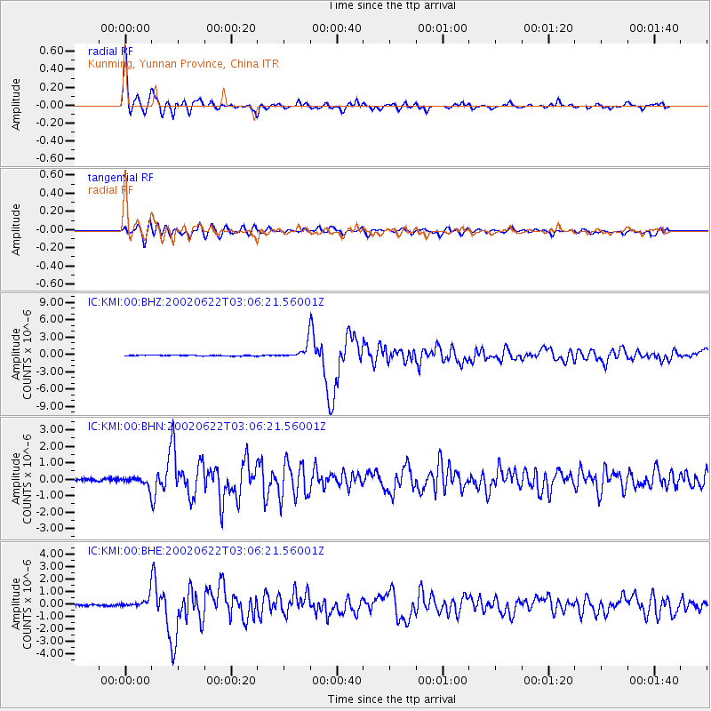
KMI Kunming, Yunnan Province, China |
| Lat/Lon: |
25.12 N/102.74 E |
| Elevation: |
1975 m |
|
| Distance: |
47.0 deg |
| Az: |
87.435 deg |
| Baz: |
296.126 deg |
| Ray Param: |
0.07028849 |
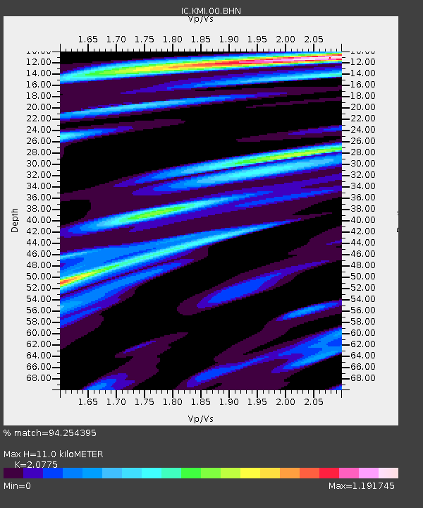
| Estimated Moho Depth: |
11.0 km |
| Estimated Crust Vp/Vs: |
2.08 |
| Assumed Crust Vp: |
6.247 km/s |
| Estimated Crust Vs: |
3.007 km/s |
| Estimated Crust Poisson's Ratio: |
0.35 |
|
| Radial Match: |
94.254395 % |
| Radial Bump: |
388 |
| Transverse Match: |
83.36658 % |
| Transverse Bump: |
400 |
| SOD ConfigId: |
20082 |
| Insert Time: |
2010-03-04 22:24:11.881 +0000 |
| GWidth: |
2.5 |
| Max Bumps: |
400 |
| Tol: |
0.001 |
|
Signal To Noise
| Channel | StoN | STA | LTA |
| IC:KMI:00:BHN:20020622T03:06:21.56001Z | 3.8830419 | 3.08753E-7 | 7.951318E-8 |
| IC:KMI:00:BHE:20020622T03:06:21.56001Z | 7.4885798 | 4.6630436E-7 | 6.226873E-8 |
| IC:KMI:00:BHZ:20020622T03:06:21.56001Z | 17.322723 | 1.2540903E-6 | 7.239567E-8 |
| Arrivals |
| Ps | 2.0 SECOND |
| PpPs | 5.2 SECOND |
| PsPs/PpSs | 7.2 SECOND |


