You are here: Home > Network List > IC - New China Digital Seismograph Network Stations List
> Station KMI Kunming, Yunnan Province, China > Earthquake Result Viewer
KMI Kunming, Yunnan Province, China - Earthquake Result Viewer
| Earthquake location: |
Southeast Indian Ridge |
| Earthquake latitude/longitude: |
-47.8/99.8 |
| Earthquake time(UTC): |
2002/06/13 (164) 01:27:19 GMT |
| Earthquake Depth: |
10 km |
| Earthquake Magnitude: |
5.5 MB, 6.6 MS, 6.6 MW, 6.5 MW |
| Earthquake Catalog/Contributor: |
WHDF/NEIC |
|
| Network: |
IC New China Digital Seismograph Network |
| Station: |
KMI Kunming, Yunnan Province, China |
| Lat/Lon: |
25.12 N/102.74 E |
| Elevation: |
1975 m |
|
| Distance: |
72.6 deg |
| Az: |
2.839 deg |
| Baz: |
182.111 deg |
| Ray Param: |
0.053530872 |
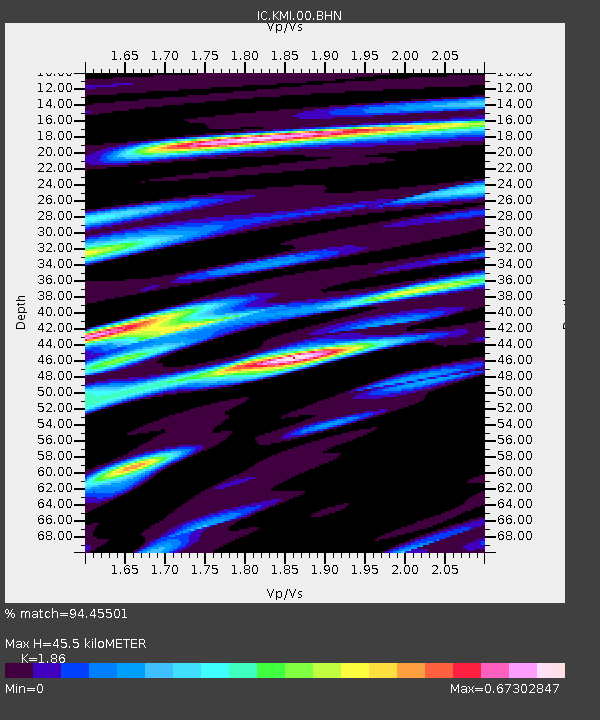
| Estimated Moho Depth: |
45.5 km |
| Estimated Crust Vp/Vs: |
1.86 |
| Assumed Crust Vp: |
6.247 km/s |
| Estimated Crust Vs: |
3.358 km/s |
| Estimated Crust Poisson's Ratio: |
0.30 |
|
| Radial Match: |
94.45501 % |
| Radial Bump: |
400 |
| Transverse Match: |
91.27188 % |
| Transverse Bump: |
400 |
| SOD ConfigId: |
20082 |
| Insert Time: |
2010-03-04 22:24:13.640 +0000 |
| GWidth: |
2.5 |
| Max Bumps: |
400 |
| Tol: |
0.001 |
|
Signal To Noise
| Channel | StoN | STA | LTA |
| IC:KMI:00:BHN:20020613T01:38:15.811003Z | 0.79431427 | 5.9315457E-8 | 7.467505E-8 |
| IC:KMI:00:BHE:20020613T01:38:15.811003Z | 0.9973038 | 6.403675E-8 | 6.4209864E-8 |
| IC:KMI:00:BHZ:20020613T01:38:15.811003Z | 2.3398614 | 1.3688135E-7 | 5.849977E-8 |
| Arrivals |
| Ps | 6.5 SECOND |
| PpPs | 20 SECOND |
| PsPs/PpSs | 27 SECOND |


