You are here: Home > Network List > N4 - Central and EAstern US Network Stations List
> Station S61A Accomac, VA, USA > Earthquake Result Viewer
S61A Accomac, VA, USA - Earthquake Result Viewer
| Earthquake location: |
Peru-Brazil Border Region |
| Earthquake latitude/longitude: |
-9.2/-71.3 |
| Earthquake time(UTC): |
2015/11/26 (330) 05:45:18 GMT |
| Earthquake Depth: |
604 km |
| Earthquake Magnitude: |
6.4 MWP |
| Earthquake Catalog/Contributor: |
NEIC PDE/NEIC COMCAT |
|
| Network: |
N4 Central and EAstern US Network |
| Station: |
S61A Accomac, VA, USA |
| Lat/Lon: |
37.68 N/75.67 W |
| Elevation: |
58 m |
|
| Distance: |
46.8 deg |
| Az: |
355.211 deg |
| Baz: |
174.037 deg |
| Ray Param: |
0.06742683 |
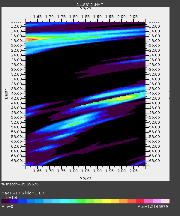
| Estimated Moho Depth: |
17.5 km |
| Estimated Crust Vp/Vs: |
1.60 |
| Assumed Crust Vp: |
5.817 km/s |
| Estimated Crust Vs: |
3.636 km/s |
| Estimated Crust Poisson's Ratio: |
0.18 |
|
| Radial Match: |
85.59576 % |
| Radial Bump: |
397 |
| Transverse Match: |
43.53554 % |
| Transverse Bump: |
368 |
| SOD ConfigId: |
7422571 |
| Insert Time: |
2019-04-21 12:07:25.722 +0000 |
| GWidth: |
2.5 |
| Max Bumps: |
400 |
| Tol: |
0.001 |
|
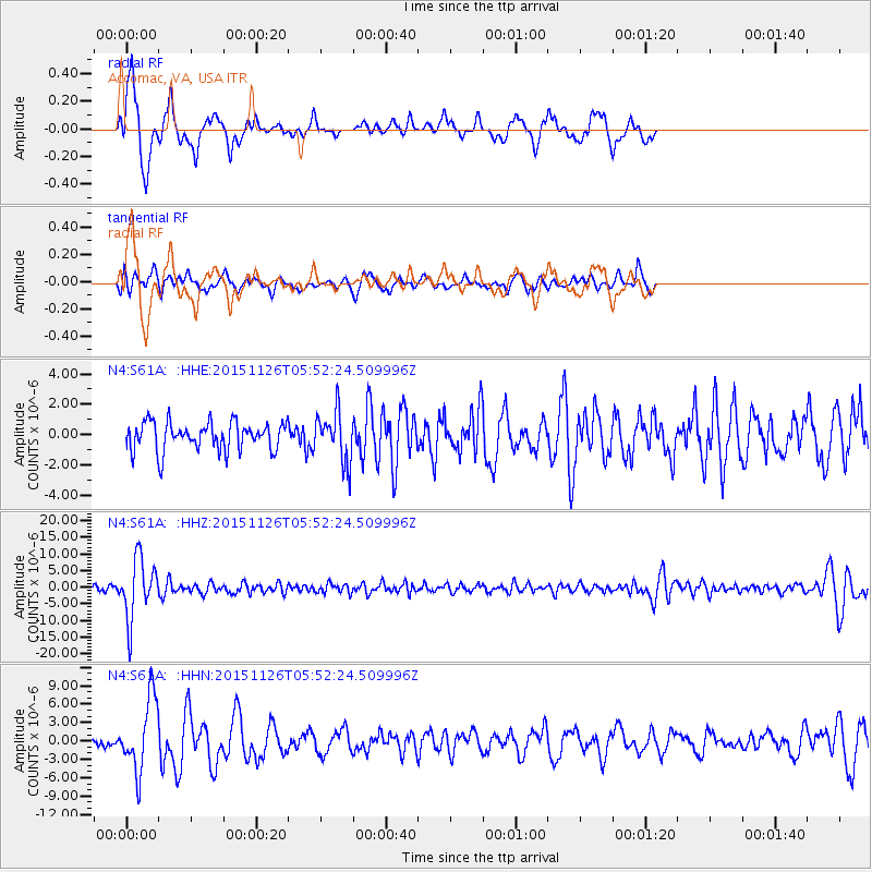
Signal To Noise
| Channel | StoN | STA | LTA |
| N4:S61A: :HHZ:20151126T05:52:24.509996Z | 6.3928485 | 9.009E-6 | 1.409231E-6 |
| N4:S61A: :HHN:20151126T05:52:24.509996Z | 5.953628 | 5.989463E-6 | 1.006019E-6 |
| N4:S61A: :HHE:20151126T05:52:24.509996Z | 1.7363826 | 1.6161569E-6 | 9.3076073E-7 |
| Arrivals |
| Ps | 1.9 SECOND |
| PpPs | 7.4 SECOND |
| PsPs/PpSs | 9.3 SECOND |


