You are here: Home > Network List > IC - New China Digital Seismograph Network Stations List
> Station KMI Kunming, Yunnan Province, China > Earthquake Result Viewer
KMI Kunming, Yunnan Province, China - Earthquake Result Viewer
| Earthquake location: |
South Of Alaska |
| Earthquake latitude/longitude: |
53.8/-161.1 |
| Earthquake time(UTC): |
2002/05/25 (145) 05:36:31 GMT |
| Earthquake Depth: |
33 km |
| Earthquake Magnitude: |
5.5 MB, 6.1 MS, 6.5 MW, 6.4 MW |
| Earthquake Catalog/Contributor: |
WHDF/NEIC |
|
| Network: |
IC New China Digital Seismograph Network |
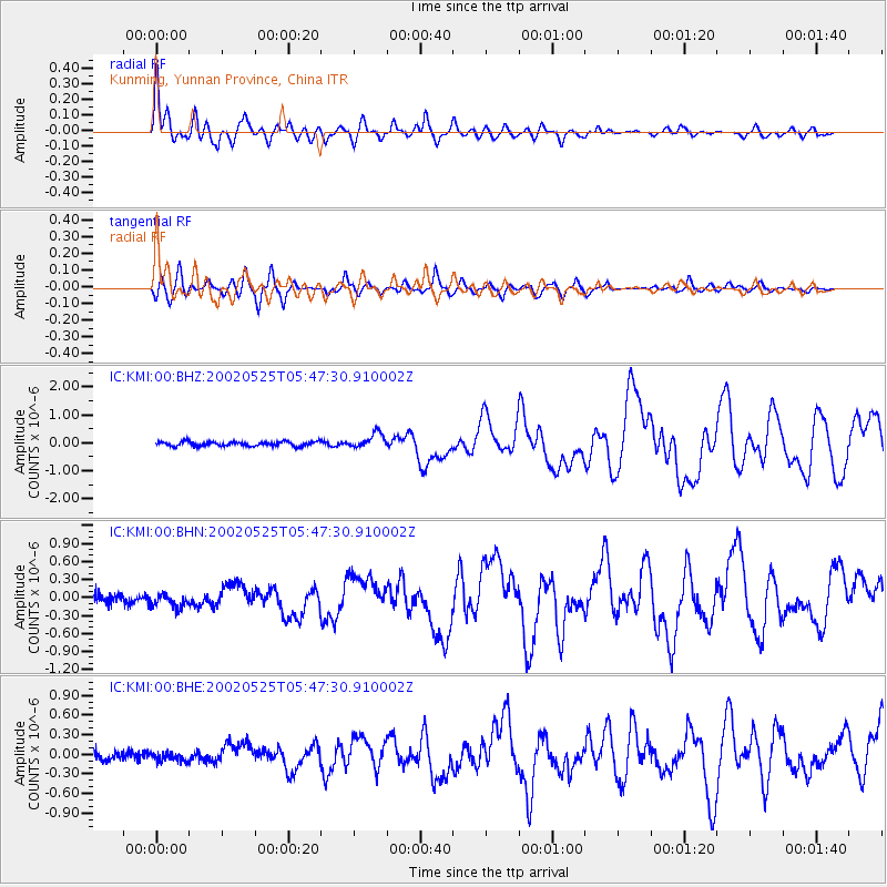
| Station: |
KMI Kunming, Yunnan Province, China |
| Lat/Lon: |
25.12 N/102.74 E |
| Elevation: |
1975 m |
|
| Distance: |
73.6 deg |
| Az: |
290.026 deg |
| Baz: |
37.923 deg |
| Ray Param: |
0.052852787 |
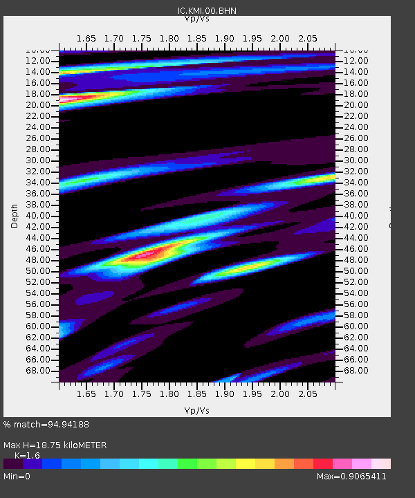
| Estimated Moho Depth: |
18.75 km |
| Estimated Crust Vp/Vs: |
1.60 |
| Assumed Crust Vp: |
6.247 km/s |
| Estimated Crust Vs: |
3.904 km/s |
| Estimated Crust Poisson's Ratio: |
0.18 |
|
| Radial Match: |
94.94188 % |
| Radial Bump: |
400 |
| Transverse Match: |
85.00039 % |
| Transverse Bump: |
400 |
| SOD ConfigId: |
20082 |
| Insert Time: |
2010-03-04 22:24:18.790 +0000 |
| GWidth: |
2.5 |
| Max Bumps: |
400 |
| Tol: |
0.001 |
|
Signal To Noise
| Channel | StoN | STA | LTA |
| IC:KMI:00:BHN:20020525T05:47:30.910002Z | 1.6027993 | 1.18191515E-7 | 7.374068E-8 |
| IC:KMI:00:BHE:20020525T05:47:30.910002Z | 1.1199138 | 7.345992E-8 | 6.5594264E-8 |
| IC:KMI:00:BHZ:20020525T05:47:30.910002Z | 3.3803585 | 2.6183014E-7 | 7.745633E-8 |
| Arrivals |
| Ps | 1.9 SECOND |
| PpPs | 7.5 SECOND |
| PsPs/PpSs | 9.4 SECOND |


