You are here: Home > Network List > N4 - Central and EAstern US Network Stations List
> Station W45B Hickory Valley, TN, USA > Earthquake Result Viewer
W45B Hickory Valley, TN, USA - Earthquake Result Viewer
| Earthquake location: |
Peru-Brazil Border Region |
| Earthquake latitude/longitude: |
-9.2/-71.3 |
| Earthquake time(UTC): |
2015/11/26 (330) 05:45:18 GMT |
| Earthquake Depth: |
604 km |
| Earthquake Magnitude: |
6.4 MWP |
| Earthquake Catalog/Contributor: |
NEIC PDE/NEIC COMCAT |
|
| Network: |
N4 Central and EAstern US Network |
| Station: |
W45B Hickory Valley, TN, USA |
| Lat/Lon: |
35.16 N/89.19 W |
| Elevation: |
182 m |
|
| Distance: |
47.3 deg |
| Az: |
339.936 deg |
| Baz: |
155.585 deg |
| Ray Param: |
0.0671583 |
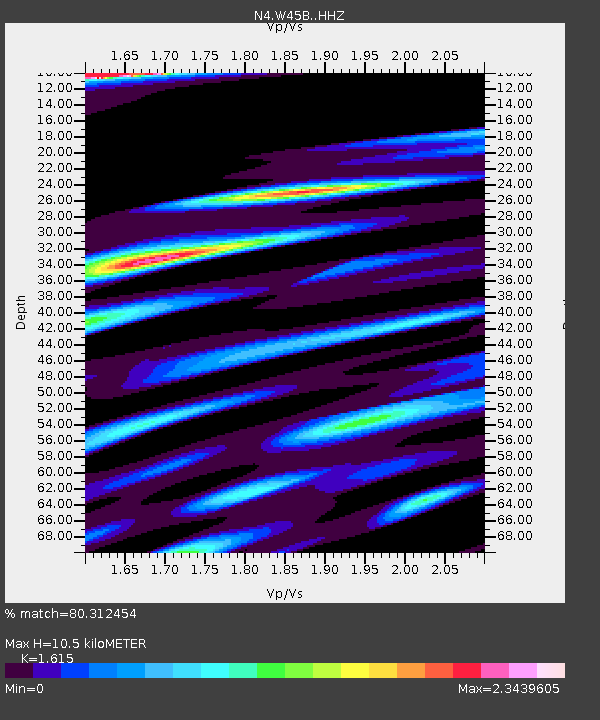
| Estimated Moho Depth: |
10.5 km |
| Estimated Crust Vp/Vs: |
1.62 |
| Assumed Crust Vp: |
6.38 km/s |
| Estimated Crust Vs: |
3.951 km/s |
| Estimated Crust Poisson's Ratio: |
0.19 |
|
| Radial Match: |
80.312454 % |
| Radial Bump: |
385 |
| Transverse Match: |
63.682816 % |
| Transverse Bump: |
400 |
| SOD ConfigId: |
7422571 |
| Insert Time: |
2019-04-21 12:07:39.301 +0000 |
| GWidth: |
2.5 |
| Max Bumps: |
400 |
| Tol: |
0.001 |
|

Signal To Noise
| Channel | StoN | STA | LTA |
| N4:W45B: :HHZ:20151126T05:52:27.840013Z | 25.288269 | 4.4817975E-6 | 1.7722832E-7 |
| N4:W45B: :HHN:20151126T05:52:27.840013Z | 8.213047 | 4.3878076E-6 | 5.3424844E-7 |
| N4:W45B: :HHE:20151126T05:52:27.840013Z | 5.7406607 | 2.3743164E-6 | 4.1359638E-7 |
| Arrivals |
| Ps | 1.1 SECOND |
| PpPs | 4.0 SECOND |
| PsPs/PpSs | 5.1 SECOND |


