You are here: Home > Network List > IC - New China Digital Seismograph Network Stations List
> Station KMI Kunming, Yunnan Province, China > Earthquake Result Viewer
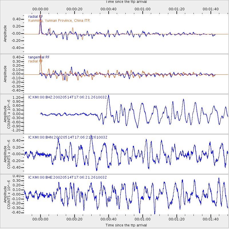
KMI Kunming, Yunnan Province, China - Earthquake Result Viewer

| Earthquake location: |
Mid-Indian Ridge |
| Earthquake latitude/longitude: |
-36.5/78.9 |
| Earthquake time(UTC): |
2002/05/14 (134) 16:56:10 GMT |
| Earthquake Depth: |
10 km |
| Earthquake Magnitude: |
5.6 MB, 6.1 MS, 6.3 MW, 6.1 MW |
| Earthquake Catalog/Contributor: |
WHDF/NEIC |
|
| Network: |
IC New China Digital Seismograph Network |
| Station: |
KMI Kunming, Yunnan Province, China |
| Lat/Lon: |
25.12 N/102.74 E |
| Elevation: |
1975 m |
|
| Distance: |
65.3 deg |
| Az: |
23.753 deg |
| Baz: |
200.974 deg |
| Ray Param: |
0.058365196 |
| Estimated Moho Depth: |
42.0 km |
| Estimated Crust Vp/Vs: |
1.69 |
| Assumed Crust Vp: |
6.247 km/s |
| Estimated Crust Vs: |
3.696 km/s |
| Estimated Crust Poisson's Ratio: |
0.23 |
|
| Radial Match: |
92.49039 % |
| Radial Bump: |
340 |
| Transverse Match: |
85.05429 % |
| Transverse Bump: |
400 |
| SOD ConfigId: |
20082 |
| Insert Time: |
2010-03-04 22:24:22.177 +0000 |
| GWidth: |
2.5 |
| Max Bumps: |
400 |
| Tol: |
0.001 |
|
Signal To Noise
| Channel | StoN | STA | LTA |
| IC:KMI:00:BHN:20020514T17:06:21.261003Z | 0.70226014 | 3.5993835E-8 | 5.125428E-8 |
| IC:KMI:00:BHE:20020514T17:06:21.261003Z | 0.59117967 | 3.1357345E-8 | 5.3041983E-8 |
| IC:KMI:00:BHZ:20020514T17:06:21.261003Z | 3.51214 | 1.5947157E-7 | 4.540581E-8 |
| Arrivals |
| Ps | 4.8 SECOND |
| PpPs | 17 SECOND |
| PsPs/PpSs | 22 SECOND |


