You are here: Home > Network List > N4 - Central and EAstern US Network Stations List
> Station Y58A Scranton, SC, USA > Earthquake Result Viewer
Y58A Scranton, SC, USA - Earthquake Result Viewer
| Earthquake location: |
Peru-Brazil Border Region |
| Earthquake latitude/longitude: |
-9.2/-71.3 |
| Earthquake time(UTC): |
2015/11/26 (330) 05:45:18 GMT |
| Earthquake Depth: |
604 km |
| Earthquake Magnitude: |
6.4 MWP |
| Earthquake Catalog/Contributor: |
NEIC PDE/NEIC COMCAT |
|
| Network: |
N4 Central and EAstern US Network |
| Station: |
Y58A Scranton, SC, USA |
| Lat/Lon: |
33.91 N/79.67 W |
| Elevation: |
19 m |
|
| Distance: |
43.6 deg |
| Az: |
349.863 deg |
| Baz: |
167.942 deg |
| Ray Param: |
0.06935946 |
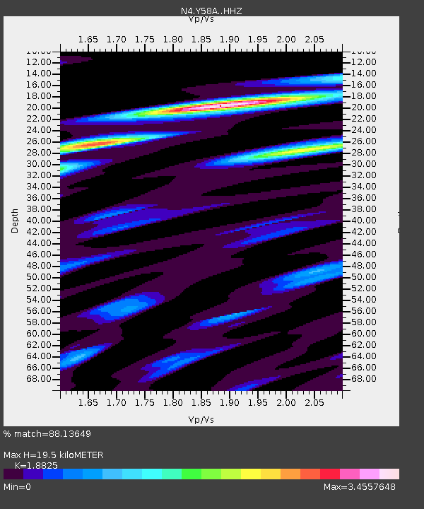
| Estimated Moho Depth: |
19.5 km |
| Estimated Crust Vp/Vs: |
1.88 |
| Assumed Crust Vp: |
6.24 km/s |
| Estimated Crust Vs: |
3.315 km/s |
| Estimated Crust Poisson's Ratio: |
0.30 |
|
| Radial Match: |
88.13649 % |
| Radial Bump: |
334 |
| Transverse Match: |
64.45111 % |
| Transverse Bump: |
400 |
| SOD ConfigId: |
7422571 |
| Insert Time: |
2019-04-21 12:07:48.068 +0000 |
| GWidth: |
2.5 |
| Max Bumps: |
400 |
| Tol: |
0.001 |
|

Signal To Noise
| Channel | StoN | STA | LTA |
| N4:Y58A: :HHZ:20151126T05:52:00.140001Z | 21.824247 | 7.980626E-6 | 3.65677E-7 |
| N4:Y58A: :HHN:20151126T05:52:00.140001Z | 15.836965 | 1.1934651E-5 | 7.535947E-7 |
| N4:Y58A: :HHE:20151126T05:52:00.140001Z | 2.6568458 | 2.6836587E-6 | 1.010092E-6 |
| Arrivals |
| Ps | 2.9 SECOND |
| PpPs | 8.5 SECOND |
| PsPs/PpSs | 11 SECOND |


