You are here: Home > Network List > IC - New China Digital Seismograph Network Stations List
> Station KMI Kunming, Yunnan Province, China > Earthquake Result Viewer
KMI Kunming, Yunnan Province, China - Earthquake Result Viewer
| Earthquake location: |
Banda Sea |
| Earthquake latitude/longitude: |
-6.5/129.9 |
| Earthquake time(UTC): |
2002/03/19 (078) 22:14:14 GMT |
| Earthquake Depth: |
148 km |
| Earthquake Magnitude: |
5.7 MB, 6.1 MW, 6.0 MW |
| Earthquake Catalog/Contributor: |
WHDF/NEIC |
|
| Network: |
IC New China Digital Seismograph Network |
| Station: |
KMI Kunming, Yunnan Province, China |
| Lat/Lon: |
25.12 N/102.74 E |
| Elevation: |
1975 m |
|
| Distance: |
41.1 deg |
| Az: |
320.949 deg |
| Baz: |
136.321 deg |
| Ray Param: |
0.07346697 |
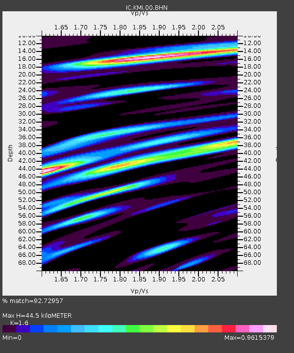
| Estimated Moho Depth: |
44.5 km |
| Estimated Crust Vp/Vs: |
1.60 |
| Assumed Crust Vp: |
6.247 km/s |
| Estimated Crust Vs: |
3.904 km/s |
| Estimated Crust Poisson's Ratio: |
0.18 |
|
| Radial Match: |
92.72957 % |
| Radial Bump: |
400 |
| Transverse Match: |
87.0401 % |
| Transverse Bump: |
400 |
| SOD ConfigId: |
20082 |
| Insert Time: |
2010-03-04 22:24:27.211 +0000 |
| GWidth: |
2.5 |
| Max Bumps: |
400 |
| Tol: |
0.001 |
|
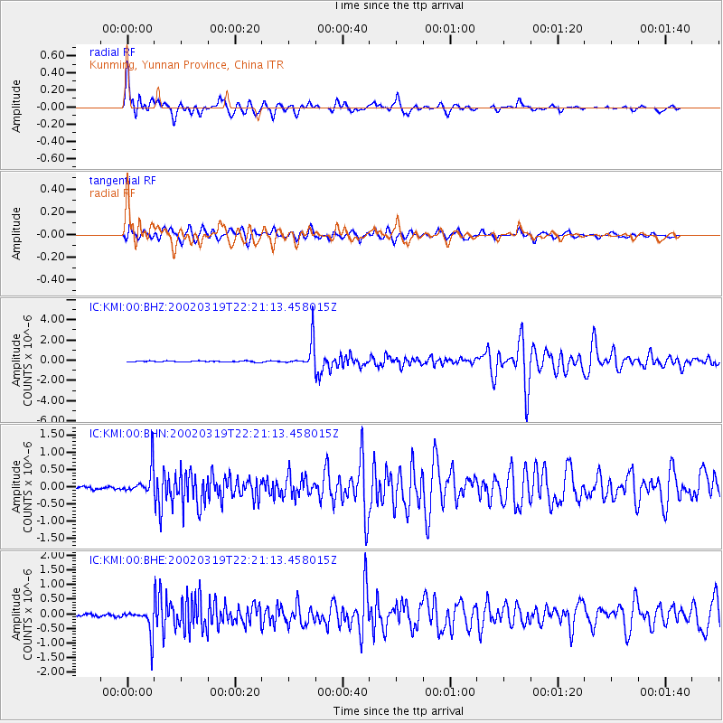
Signal To Noise
| Channel | StoN | STA | LTA |
| IC:KMI:00:BHN:20020319T22:21:13.458015Z | 7.157353 | 4.0606014E-7 | 5.6733285E-8 |
| IC:KMI:00:BHE:20020319T22:21:13.458015Z | 11.996442 | 4.5473473E-7 | 3.79058E-8 |
| IC:KMI:00:BHZ:20020319T22:21:13.458015Z | 25.094618 | 1.3316128E-6 | 5.3063683E-8 |
| Arrivals |
| Ps | 4.6 SECOND |
| PpPs | 17 SECOND |
| PsPs/PpSs | 22 SECOND |


