You are here: Home > Network List > NX - Nanometrics Research Network Stations List
> Station STN18 Seismic station 18 > Earthquake Result Viewer
STN18 Seismic station 18 - Earthquake Result Viewer
| Earthquake location: |
Peru-Brazil Border Region |
| Earthquake latitude/longitude: |
-9.2/-71.3 |
| Earthquake time(UTC): |
2015/11/26 (330) 05:45:18 GMT |
| Earthquake Depth: |
604 km |
| Earthquake Magnitude: |
6.4 MWP |
| Earthquake Catalog/Contributor: |
NEIC PDE/NEIC COMCAT |
|
| Network: |
NX Nanometrics Research Network |
| Station: |
STN18 Seismic station 18 |
| Lat/Lon: |
36.42 N/96.65 W |
| Elevation: |
255 m |
|
| Distance: |
51.3 deg |
| Az: |
333.707 deg |
| Baz: |
147.169 deg |
| Ray Param: |
0.064710796 |
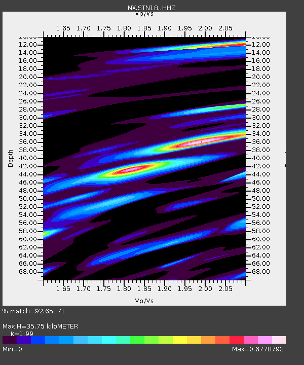
| Estimated Moho Depth: |
35.75 km |
| Estimated Crust Vp/Vs: |
1.99 |
| Assumed Crust Vp: |
6.483 km/s |
| Estimated Crust Vs: |
3.258 km/s |
| Estimated Crust Poisson's Ratio: |
0.33 |
|
| Radial Match: |
92.65171 % |
| Radial Bump: |
351 |
| Transverse Match: |
66.684326 % |
| Transverse Bump: |
400 |
| SOD ConfigId: |
7422571 |
| Insert Time: |
2019-04-21 12:08:47.861 +0000 |
| GWidth: |
2.5 |
| Max Bumps: |
400 |
| Tol: |
0.001 |
|

Signal To Noise
| Channel | StoN | STA | LTA |
| NX:STN18: :HHZ:20151126T05:52:57.219988Z | 34.41207 | 6.0819143E-6 | 1.7673781E-7 |
| NX:STN18: :HH1:20151126T05:52:57.219988Z | 20.844099 | 2.9464693E-6 | 1.4135748E-7 |
| NX:STN18: :HH2:20151126T05:52:57.219988Z | 14.007333 | 2.0787475E-6 | 1.4840423E-7 |
| Arrivals |
| Ps | 5.7 SECOND |
| PpPs | 16 SECOND |
| PsPs/PpSs | 21 SECOND |


