You are here: Home > Network List > NX - Nanometrics Research Network Stations List
> Station STN20 Seismic station 20 > Earthquake Result Viewer
STN20 Seismic station 20 - Earthquake Result Viewer
| Earthquake location: |
Peru-Brazil Border Region |
| Earthquake latitude/longitude: |
-9.2/-71.3 |
| Earthquake time(UTC): |
2015/11/26 (330) 05:45:18 GMT |
| Earthquake Depth: |
604 km |
| Earthquake Magnitude: |
6.4 MWP |
| Earthquake Catalog/Contributor: |
NEIC PDE/NEIC COMCAT |
|
| Network: |
NX Nanometrics Research Network |
| Station: |
STN20 Seismic station 20 |
| Lat/Lon: |
36.52 N/97.74 W |
| Elevation: |
339 m |
|
| Distance: |
51.9 deg |
| Az: |
332.838 deg |
| Baz: |
145.981 deg |
| Ray Param: |
0.06436218 |
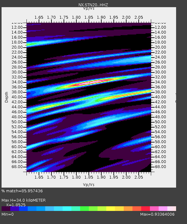
| Estimated Moho Depth: |
34.0 km |
| Estimated Crust Vp/Vs: |
1.85 |
| Assumed Crust Vp: |
6.483 km/s |
| Estimated Crust Vs: |
3.499 km/s |
| Estimated Crust Poisson's Ratio: |
0.29 |
|
| Radial Match: |
85.957436 % |
| Radial Bump: |
400 |
| Transverse Match: |
66.91696 % |
| Transverse Bump: |
400 |
| SOD ConfigId: |
7422571 |
| Insert Time: |
2019-04-21 12:08:48.529 +0000 |
| GWidth: |
2.5 |
| Max Bumps: |
400 |
| Tol: |
0.001 |
|

Signal To Noise
| Channel | StoN | STA | LTA |
| NX:STN20: :HHZ:20151126T05:53:01.330004Z | 38.205612 | 7.511722E-6 | 1.9661304E-7 |
| NX:STN20: :HH1:20151126T05:53:01.330004Z | 4.459342 | 1.0189401E-6 | 2.2849562E-7 |
| NX:STN20: :HH2:20151126T05:53:01.330004Z | 10.406729 | 3.2888536E-6 | 3.1603145E-7 |
| Arrivals |
| Ps | 4.7 SECOND |
| PpPs | 14 SECOND |
| PsPs/PpSs | 19 SECOND |


