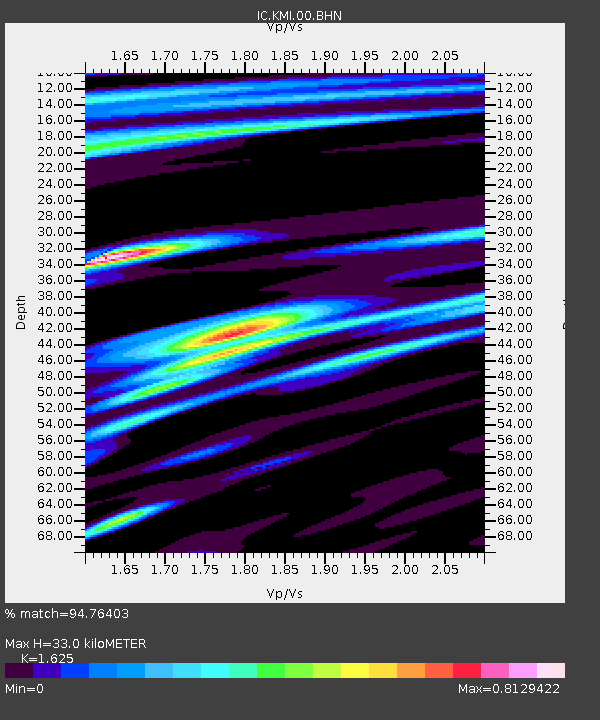
KMI Kunming, Yunnan Province, China - Earthquake Result Viewer

Earthquake location: Rat Islands, Aleutian Islands
Earthquake latitude/longitude: 51.2/179.3
Earthquake time(UTC): 2002/11/07 (311) 15:14:06 GMT
Earthquake Depth: 33 km
Earthquake Magnitude: 5.8 MB, 6.4 MS, 6.6 MW, 6.5 MW
Earthquake Catalog/Contributor: WHDF/NEIC
Network: IC New China Digital Seismograph Network
Station: KMI Kunming, Yunnan Province, China
Lat/Lon: 25.12 N/102.74 E
Elevation: 1975 m
Distance: 62.6 deg
Az: 276.619 deg
Baz: 43.589 deg
Ray Param: 0.060074527
Estimated Moho Depth: 33.0 km
Estimated Crust Vp/Vs: 1.62
Assumed Crust Vp: 6.247 km/s
Estimated Crust Vs: 3.844 km/s
Estimated Crust Poisson's Ratio: 0.20
Radial Match: 94.76403 %
Radial Bump: 400
Transverse Match: 79.635254 %
Transverse Bump: 400
SOD ConfigId: 4714
Insert Time: 2010-03-04 22:24:56.196 +0000
GWidth: 2.5
Max Bumps: 400
Tol: 0.001

Signal To Noise

ChannelStoNSTALTA
IC:KMI:00:BHN:20021107T15:23:56.809011Z2.97785691.815991E-76.0983155E-8
IC:KMI:00:BHE:20021107T15:23:56.809011Z1.63002511.267375E-77.775187E-8
IC:KMI:00:BHZ:20021107T15:23:56.809011Z10.5495745.145512E-74.877459E-8
Arrivals
Ps3.5 SECOND
PpPs13 SECOND
PsPs/PpSs17 SECOND