You are here: Home > Network List > IC - New China Digital Seismograph Network Stations List
> Station KMI Kunming, Yunnan Province, China > Earthquake Result Viewer
KMI Kunming, Yunnan Province, China - Earthquake Result Viewer
| Earthquake location: |
Central Alaska |
| Earthquake latitude/longitude: |
63.5/-147.4 |
| Earthquake time(UTC): |
2002/11/03 (307) 22:12:41 GMT |
| Earthquake Depth: |
4.9 km |
| Earthquake Magnitude: |
7.0 MB, 8.5 MS, 7.9 MW |
| Earthquake Catalog/Contributor: |
WHDF/NEIC |
|
| Network: |
IC New China Digital Seismograph Network |
| Station: |
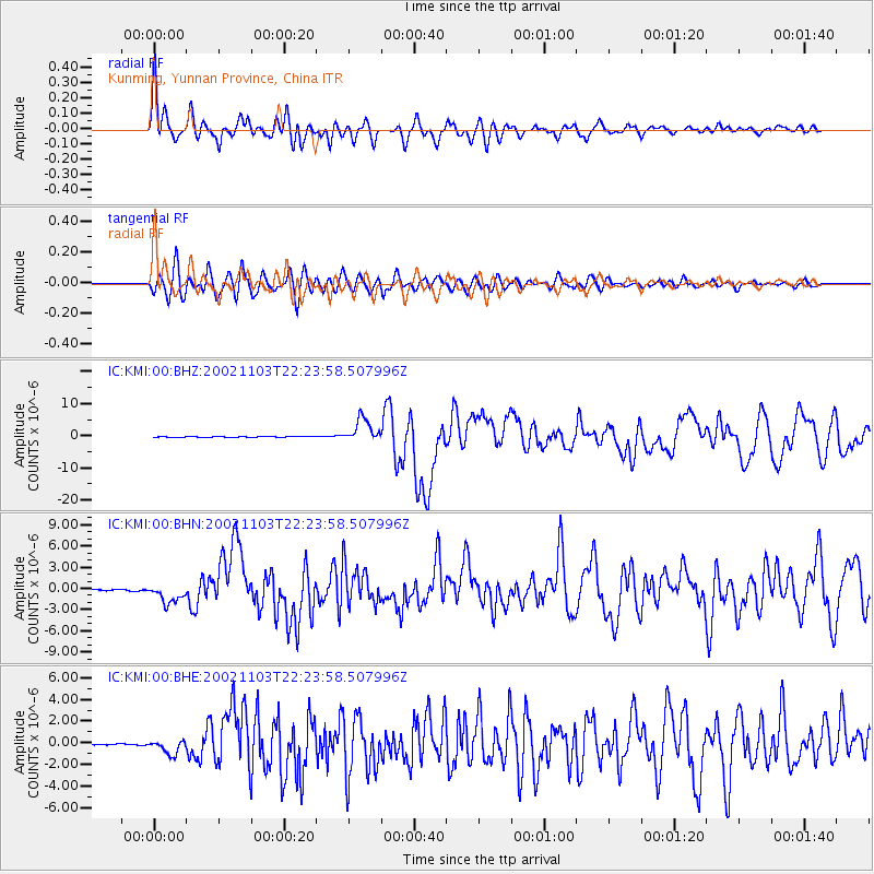
KMI Kunming, Yunnan Province, China |
| Lat/Lon: |
25.12 N/102.74 E |
| Elevation: |
1975 m |
|
| Distance: |
76.1 deg |
| Az: |
298.549 deg |
| Baz: |
25.75 deg |
| Ray Param: |
0.051208165 |
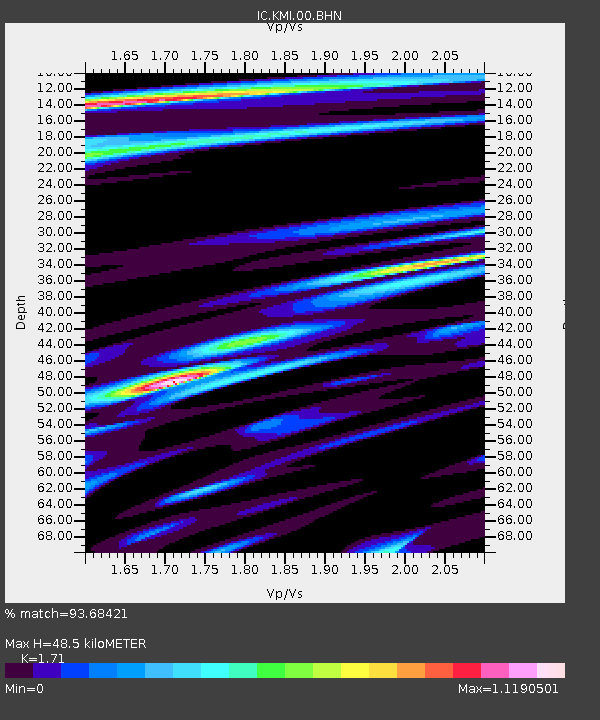
| Estimated Moho Depth: |
48.5 km |
| Estimated Crust Vp/Vs: |
1.71 |
| Assumed Crust Vp: |
6.247 km/s |
| Estimated Crust Vs: |
3.653 km/s |
| Estimated Crust Poisson's Ratio: |
0.24 |
|
| Radial Match: |
93.68421 % |
| Radial Bump: |
400 |
| Transverse Match: |
86.630226 % |
| Transverse Bump: |
400 |
| SOD ConfigId: |
4714 |
| Insert Time: |
2010-03-04 22:24:58.056 +0000 |
| GWidth: |
2.5 |
| Max Bumps: |
400 |
| Tol: |
0.001 |
|
Signal To Noise
| Channel | StoN | STA | LTA |
| IC:KMI:00:BHN:20021103T22:23:58.507996Z | 16.40619 | 1.3733197E-6 | 8.370741E-8 |
| IC:KMI:00:BHE:20021103T22:23:58.507996Z | 9.473558 | 6.708279E-7 | 7.081055E-8 |
| IC:KMI:00:BHZ:20021103T22:23:58.507996Z | 24.751623 | 3.6335487E-6 | 1.4680042E-7 |
| Arrivals |
| Ps | 5.7 SECOND |
| PpPs | 20 SECOND |
| PsPs/PpSs | 26 SECOND |


