You are here: Home > Network List > PE - Penn State Network Stations List
> Station PAGS PA Geological Survey, Middletown, PA > Earthquake Result Viewer
PAGS PA Geological Survey, Middletown, PA - Earthquake Result Viewer

| Earthquake location: |
Peru-Brazil Border Region |
| Earthquake latitude/longitude: |
-9.2/-71.3 |
| Earthquake time(UTC): |
2015/11/26 (330) 05:45:18 GMT |
| Earthquake Depth: |
604 km |
| Earthquake Magnitude: |
6.4 MWP |
| Earthquake Catalog/Contributor: |
NEIC PDE/NEIC COMCAT |
|
| Network: |
PE Penn State Network |
| Station: |
PAGS PA Geological Survey, Middletown, PA |
| Lat/Lon: |
40.23 N/76.72 W |
| Elevation: |
120 m |
|
| Distance: |
49.5 deg |
| Az: |
354.51 deg |
| Baz: |
172.914 deg |
| Ray Param: |
0.0658197 |
| Estimated Moho Depth: |
16.25 km |
| Estimated Crust Vp/Vs: |
1.77 |
| Assumed Crust Vp: |
6.121 km/s |
| Estimated Crust Vs: |
3.448 km/s |
| Estimated Crust Poisson's Ratio: |
0.27 |
|
| Radial Match: |
85.23402 % |
| Radial Bump: |
400 |
| Transverse Match: |
58.510098 % |
| Transverse Bump: |
400 |
| SOD ConfigId: |
7422571 |
| Insert Time: |
2019-04-21 12:09:18.971 +0000 |
| GWidth: |
2.5 |
| Max Bumps: |
400 |
| Tol: |
0.001 |
|
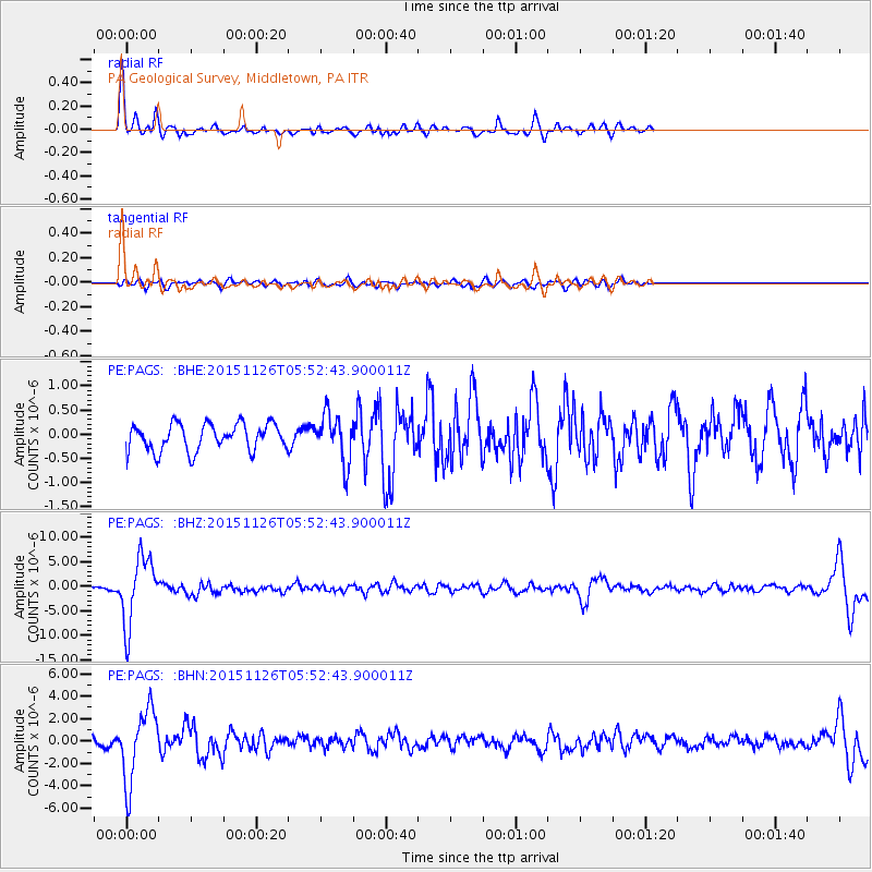
Signal To Noise
| Channel | StoN | STA | LTA |
| PE:PAGS: :BHZ:20151126T05:52:43.900011Z | 20.251684 | 6.824275E-6 | 3.3697322E-7 |
| PE:PAGS: :BHN:20151126T05:52:43.900011Z | 9.655107 | 3.2389514E-6 | 3.3546513E-7 |
| PE:PAGS: :BHE:20151126T05:52:43.900011Z | 1.848961 | 5.0766374E-7 | 2.7456704E-7 |
| Arrivals |
| Ps | 2.2 SECOND |
| PpPs | 7.0 SECOND |
| PsPs/PpSs | 9.2 SECOND |


