You are here: Home > Network List > PE - Penn State Network Stations List
> Station UPAO University of Pittsburgh - Allegheny Observatory > Earthquake Result Viewer
UPAO University of Pittsburgh - Allegheny Observatory - Earthquake Result Viewer

| Earthquake location: |
Peru-Brazil Border Region |
| Earthquake latitude/longitude: |
-9.2/-71.3 |
| Earthquake time(UTC): |
2015/11/26 (330) 05:45:18 GMT |
| Earthquake Depth: |
604 km |
| Earthquake Magnitude: |
6.4 MWP |
| Earthquake Catalog/Contributor: |
NEIC PDE/NEIC COMCAT |
|
| Network: |
PE Penn State Network |
| Station: |
UPAO University of Pittsburgh - Allegheny Observatory |
| Lat/Lon: |
40.48 N/80.02 W |
| Elevation: |
274 m |
|
| Distance: |
50.1 deg |
| Az: |
351.302 deg |
| Baz: |
168.712 deg |
| Ray Param: |
0.06543158 |
| Estimated Moho Depth: |
43.5 km |
| Estimated Crust Vp/Vs: |
1.77 |
| Assumed Crust Vp: |
6.483 km/s |
| Estimated Crust Vs: |
3.657 km/s |
| Estimated Crust Poisson's Ratio: |
0.27 |
|
| Radial Match: |
81.476494 % |
| Radial Bump: |
400 |
| Transverse Match: |
79.21979 % |
| Transverse Bump: |
400 |
| SOD ConfigId: |
7422571 |
| Insert Time: |
2019-04-21 12:09:20.690 +0000 |
| GWidth: |
2.5 |
| Max Bumps: |
400 |
| Tol: |
0.001 |
|
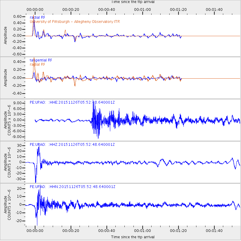
Signal To Noise
| Channel | StoN | STA | LTA |
| PE:UPAO: :HHZ:20151126T05:52:48.640001Z | 37.88427 | 1.5203074E-5 | 4.0130308E-7 |
| PE:UPAO: :HHN:20151126T05:52:48.640001Z | 26.006098 | 9.092636E-6 | 3.496348E-7 |
| PE:UPAO: :HHE:20151126T05:52:48.640001Z | 9.271095 | 3.5303049E-6 | 3.807862E-7 |
| Arrivals |
| Ps | 5.5 SECOND |
| PpPs | 18 SECOND |
| PsPs/PpSs | 23 SECOND |


