You are here: Home > Network List > PM - Portuguese National Seismic Network Stations List
> Station PFVI PM.PFVI > Earthquake Result Viewer
PFVI PM.PFVI - Earthquake Result Viewer
| Earthquake location: |
Peru-Brazil Border Region |
| Earthquake latitude/longitude: |
-9.2/-71.3 |
| Earthquake time(UTC): |
2015/11/26 (330) 05:45:18 GMT |
| Earthquake Depth: |
604 km |
| Earthquake Magnitude: |
6.4 MWP |
| Earthquake Catalog/Contributor: |
NEIC PDE/NEIC COMCAT |
|
| Network: |
PM Portuguese National Seismic Network |
| Station: |
PFVI PM.PFVI |
| Lat/Lon: |
37.13 N/8.83 W |
| Elevation: |
189 m |
|
| Distance: |
74.4 deg |
| Az: |
47.365 deg |
| Baz: |
245.338 deg |
| Ray Param: |
0.05037776 |
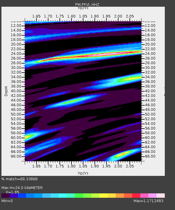
| Estimated Moho Depth: |
24.0 km |
| Estimated Crust Vp/Vs: |
1.95 |
| Assumed Crust Vp: |
6.048 km/s |
| Estimated Crust Vs: |
3.101 km/s |
| Estimated Crust Poisson's Ratio: |
0.32 |
|
| Radial Match: |
88.33988 % |
| Radial Bump: |
315 |
| Transverse Match: |
80.75452 % |
| Transverse Bump: |
295 |
| SOD ConfigId: |
7422571 |
| Insert Time: |
2019-04-21 12:09:23.036 +0000 |
| GWidth: |
2.5 |
| Max Bumps: |
400 |
| Tol: |
0.001 |
|

Signal To Noise
| Channel | StoN | STA | LTA |
| PM:PFVI: :HHZ:20151126T05:55:24.64998Z | 17.120531 | 9.189733E-6 | 5.3676683E-7 |
| PM:PFVI: :HHN:20151126T05:55:24.64998Z | 7.847538 | 1.9988556E-6 | 2.5471115E-7 |
| PM:PFVI: :HHE:20151126T05:55:24.64998Z | 6.7934456 | 2.4477715E-6 | 3.603137E-7 |
| Arrivals |
| Ps | 3.9 SECOND |
| PpPs | 11 SECOND |
| PsPs/PpSs | 15 SECOND |


